livescience.com
In the south-central part of Utah, a 100-mile-long (161 kilometers) formation, dubbed Waterpocket Fold, has created a landscape that is not only spectacular to view but is also a geological treasure for research and study.
livescience.com
In the south-central part of Utah, a 100-mile-long (161 kilometers) formation, dubbed Waterpocket Fold, has created a landscape that is not only spectacular to view but is also a geological treasure for research and study.
Maybe some of you have seen the new movie “San Andreas.” So what could we expect to happen in the event of a giant earthquake on the San Andreas Fault? Read more in this article to find out.
smithsonianmag.com
Like California, Utah is also earthquake country. One of the best forms of preparation is educating yourself and your family on what to do in the event of an earthquake. For more information on what you can do, see Putting Down Roots, or visit www.bereadyutah.gov.
Hey Geology students!
community.geosociety.org
The US Geological Survey (USGS) National Cooperative Geologic Mapping Program (NCGMP) in partnership with The Geological Society of America (GSA), GSA Foundation, Association of American State Geologists (AASG), American Geosciences Institute (AGI), American Institute of Professional Geologists (AIPG), and the Journal of Maps invites students to participate in the Best Student Geologic Map Competition.
FOLLOW THIS LINK for more information!

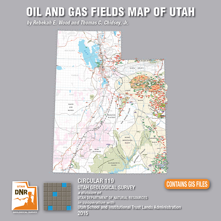
By: Rebekah E. Wood and Thomas C. Chidsey, Jr.
This CD contains an easily viewable 1:700,000-scale map in PDF format of Utah’s oil, gas, and CO₂ fields (past and present); oil gas and CO₂ pipelines with operators; field designations; names and ages of the reservoir rocks; oil refineries and natural gas processing plants; park boundaries and other geographical attributes; and some surficial geologic features. This map is to be used for a general overview and reference for hydrocarbon resources, production, transportation, and processing in Utah. Also included are geographic information system (GIS) files in ESRI file geodatabase and shapefile formats. The latest version of Adobe Reader is required to view the PDF file.
See our news release for this publication HERE
fox13now.com
Farmington Canyon will be closed for three days to allow the area to be evaluated by engineers after a large boulder fell and blocked the road Sunday.
ksl.com
A minor earthquake shook portions of northern Utah late Saturday morning, but there were no reports of damage.
Salt Lake’s oldest resident? Read more on the ancient pit home unearthed in a Salt Lake City suburb, Sandy.
smithsonianmag.com
news.nationalgeographic.com
David Roberts is a well-known mountaineer who made the first ascents of some of Alaska’s most challenging peaks. For his new book, The Lost World Of The Old Ones: Discoveries in The Ancient Southwest, he set off with a backpack to explore some of the remotest corners of the American Southwest. Rappelling down cliffs to reach ancient granaries, or stumbling across artifacts that have not been touched for 1,000 years, he follows the trail of long vanished peoples.
Give mom something special this year—show her an adventure in Utah’s beautiful backyard! Goosenecks State Park is easily accessible, and worth a visit.
ksl.com
It might take a poet several weeks to come up with the perfect words to describe the view at Goosenecks State Park.
![]()
The Utah Geological Survey (UGS) is a division of the Utah Department of Natural Resources. Several specialized programs comprise the UGS: Data Management, Energy & Minerals, Geologic Hazards, Geologic Information & Outreach, Geologic Mapping, Groundwater & Wetlands, and Paleontology.