ksl.com
The original Utahns weren’t nearly as willing to bring you a casserole, but who wants to look at fossilized Relief Society presidents?
ksl.com
The original Utahns weren’t nearly as willing to bring you a casserole, but who wants to look at fossilized Relief Society presidents?
For those of our friends that can’t get out into the outdoor wonder-world this weekend, here are some stunning photos to keep you company.
travel.nationalgeographic.com


Not everyone grows up with this kind of doll house! We’re having southern Utah geology day dreams today.
The Doll House, Maze District of Canyonlands National Park, Wayne County, Utah
Photographer: Tyler Knudsen; © 2014

The shallow waters of Bridger Bay, on the northwestern tip of Antelope Island in the southern arm of hypersaline Great Salt Lake, support extensive microbial carbonate formation, especially in the north-northeast portion of the bay near Egg Island. Lake levels in the fall of 2014 were near 60-year lows (as low as 1278.1 m [4193.3 ft] AMSL, compared to the near-term historic average of about 1280 m [4200 ft]), giving unprecedented access to the microbial structures. Characterizing the microbialites of Bridger Bay, including facies delineation and aerial extent, can inform interpretations of similar deposits in the ancient rock record (e.g., Eocene Green River Formation), including potential petroleum reservoirs.
Music:
Headphone Activist – The Rainforest.
soundcloud.com/headphoneactivist
www.facebook.com/HPABeats
upr.org
The Great Salt Lake is, right now, actually two lakes split in half by a long railroad causeway. A couple years ago the crumbling culverts that allowed flow between the north and south arms of the lake were closed for safety. Since then, scientists say, curious things are happening to the lake, especially as it approaches historic low levels.


By: Daren T. Nelson and Paul W. Jewell
The Hogup Bar quadrangle is located southeast of Park Valley, Utah, and west of the northwest arm of Great Salt Lake. Late Pleistocene Lake Bonneville sediments and related shorelines dominate the landscape, and record the transgression and regression of Lake Bonneville. Surficial deposits overlie Tertiary basalt and Permian-Pennsylvanian sedimentary bedrock.


By: Kimm N. Harty and Adam P. Mckean
This 1:24,000-scale surface fault rupture map of the Honeyville quadrangle shows potentially active faults and special-study areas for the Brigham City and Collinston segments of the Wasatch fault zone mapped using primarily 0.5-meter digital LiDAR data acquired in 2013 and 2014. Fault traces were also mapped using black and white stereographic and oblique aerial photographs and previous published sources for the Wasatch fault zone and parts of the West Cache fault zone contained on the Honeyville quadrangle.

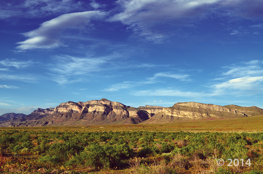
House Range, Millard County, Utah
Photographer: J. Lucy Jordan; © 2014
Where’s winter? On the upside, today feels a little like this photo—it is gorgeous out there. The mid-week peak is here with another weekend on the way. Who’s got outdoor adventures in their forecast??

This photo shows another way that #UtahGeology can really knock you off of your feet. Don’t forget your sea legs as you look out over the vast sea of geology!

San Rafael Swell and Henry Mountains from Temple Mountain, Emery County, Utah
Photographer: Paul Kuehne; © 2014
Make way for the tall, small, and furry! The Natural History Museum of Utah is presenting their latest exhibit “Extreme Mammals” this Saturday! Check out the article for more information on the exhibit.
sltrib.com
People take mammals for granted.
![]()
The Utah Geological Survey (UGS) is a division of the Utah Department of Natural Resources. Several specialized programs comprise the UGS: Data Management, Energy & Minerals, Geologic Hazards, Geologic Information & Outreach, Geologic Mapping, Groundwater & Wetlands, and Paleontology.