Tag Archive for: Uintah County

MP-16-2DM Insert

Geologic Map of The Donkey Flat Quadrangle, Uintah County, Utah

By: Paul H. Jensen, Douglas A. Sprinkel, Bart J. Kowallis, and Kent D. Brown

The Donkey Flat quadrangle is less than 10 miles north-northeast of Vernal, Utah, along the south flank of the Uinta Mountains in Uintah County. It includes Red Fleet State Park and is crossed by U.S. Highway 191 (a National Scenic Byway). The geology is well exposed and uncomplicated, making a dramatic landscape with thick sandstone cliffs and varicolored to drab gray slopes. The quadrangle’s namesake, Donkey Flat, is a one of several geomorphic surfaces mantled by piedmont gravel deposits.

GET IT HERE

OLYMPUS DIGITAL CAMERA

eastern Uinta Basin, Uintah County, Utah
Photographer: Michael Vanden Berg; © 2014

Algal stromatolites from the Green River Formation, eastern Uinta Basin, Uintah County.

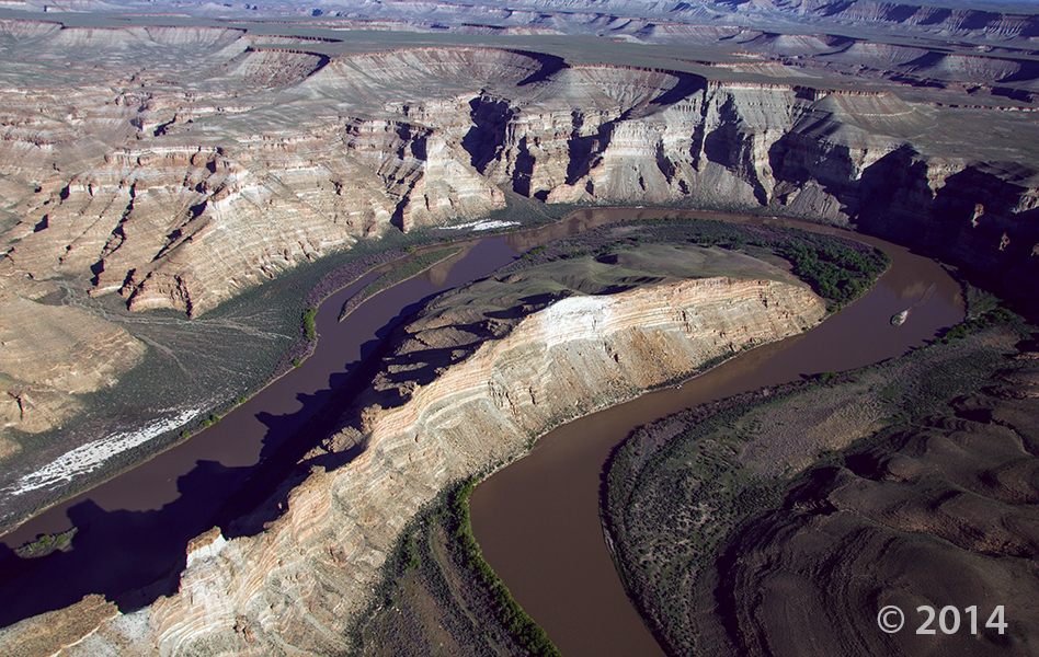
The Green River forms a dramatic “gooseneck” near Sand Wash in upper Desolation Canyon. The river has incised into rocks of the Douglas Creek and Parachute Creek Members of the Tertiary-age Green River Formation, which comprises sediments that accumulated in ancient Lake Uinta. Desolation Canyon, Uintah County, Utah Photographer: Adam Hiscock; © 2014

Hey friends, we’ve finally made way with our new website! Visit geology.utah.gov to see our new look. Though, as most technical endeavors, we’ve encountered some difficulties. Switching the URLs erased our subscription list, and those who subscribed to our “New Blog,” you will have to re-subscribe. We apologize for the inconvenience, but we hope you’ll forgive us when you see this pretty picture of Utah geology.

new-blog

POTD 2-3-15 Desolation Canyon, Uintah County, Green River

Desolation Canyon, Uintah County, Utah
Photographer: Adam Hiscock; © 2014

The Green River forms a dramatic “gooseneck” near Sand Wash in upper Desolation Canyon. The river has incised into rocks of the Douglas Creek and Parachute Creek Members of the Tertiary-age Green River Formation, which comprises sediments that accumulated in ancient Lake Uinta.

Green River, Uintah County, Utah
Photographer: Stefan Kirby; ©2011

Morning light on layered rocks of the Tertiary-age Green River Formation north of Desolation Canyon along the Green River.

Uinta Basin, Uintah County, Utah
Photographer: Michael Vanden Berg

The Mahogany oil shale zone contains the highest percentage of organic material in the Green River Formation, Uinta Basin, Uintah County.

Eastern Uinta Basin, Uintah County, Utah
Photographer: Michael Vanden Berg

Retrieving oil shale core from the Tertiary-age Green River Formation, eastern Uinta Basin, south of Bonanza near Evacuation Creek, Uintah County.

Uinta Basin, Uintah County, Utah
Photographer: Michael Vanden Berg

The exceedingly rare Graham’s penstemon grows exclusively on the sparsely vegetated outcrops of Green River Formation oil shale deposits and can be found only in the Uinta Basin of Utah and the Piceance Creek Basin in Colorado. Federal protection for this scarce plant could be forthcoming as petroleum development becomes more prevalent in the basin.

White River, southeastern Uintah County, Utah
Photographer: Robert Ressetar

The White River carved this amphitheater in the flat-lying and remarkably parallel rock layers that were deposited in a Tertiary-age lake on the south flank of the Uinta Mountains.

“Prowling Coyote” in Fantasy Canyon, Uintah County, Utah
Photographer: Jim Davis

Fantasy Canyon, Uinta Basin, Uintah County, Utah
Photographer: Jim Davis

A sandstone layer within the Eocene-aged Uinta Formation forms a surreal landscape at Fantasy Canyon. Sandwiched between more easily erodible layers of claystone and mudstone, the exposed sandstone has weathered into an intricate rock garden containing over twenty named sculptures, including “Alien Head” in the foreground.