

State Route 20, Garfield County, Utah
Photographer: Bob Biek; © 2015
Pinnacles eroded from Tertiary-age lava flow breccia along State Route 20, Garfield County.
State Route 20, Garfield County, Utah
Photographer: Bob Biek; © 2015
Pinnacles eroded from Tertiary-age lava flow breccia along State Route 20, Garfield County.


Boulder Mountain, Garfield County, Utah
Photographer: Elizabeth Firmage; © 2015
Aspen groves produce spectacular fall colors high on Boulder Mountain along the east side of the Aquarius Plateau. Large, rounded boulders eroded from Tertiary-age lava flows give Boulder Mountain its name.

Hoodoo you think you’re looking at, Bryce Canyon National Park?
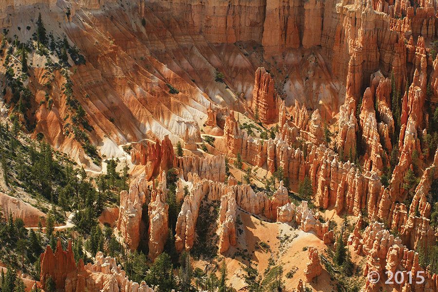
Bryce Canyon National Park, Garfield County, Utah
Photographer: Kent Brown; © 2015
Overlook from Bryce Point of fiery hoodoos in the area below Liberty Castle. Bryce Canyon hoodoos are formed in the vertically fractured pink member of the Tertiary-age Claron Formation, primarily by frost wedging and summer cloudburst rainstorms.

Hey friends, we’ve finally made way with our new website! Visit geology.utah.gov to see our new look. Though, as most technical endeavors, we’ve encountered some difficulties. Switching the URLs erased our subscription list, and those who subscribed to our “New Blog,” you will have to re-subscribe. We apologize for the inconvenience, but we hope you’ll forgive us when you see this pretty picture of Utah geology.
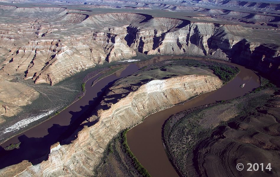
Desolation Canyon, Uintah County, Utah
Photographer: Adam Hiscock; © 2014
The Green River forms a dramatic “gooseneck” near Sand Wash in upper Desolation Canyon. The river has incised into rocks of the Douglas Creek and Parachute Creek Members of the Tertiary-age Green River Formation, which comprises sediments that accumulated in ancient Lake Uinta.
 Have a fun weekend, everyone!
Skyline Drive, Wasatch Plateau, Sanpete County, Utah
Photographer: Rich Emerson; © 2012
At 10,133 feet, winter clings to outcrops of the Tertiary-age Flagstaff Limestone near the crest of the Wasatch Plateau at Snow Lake. The steep, forested slope to the left (east) of the lake is a scarp associated with one of several faults forming a down-dropped crustal block called the Snow Lake graben.
 Green River, Uintah County, Utah
Photographer: Stefan Kirby; ©2011
Morning light on layered rocks of the Tertiary-age Green River Formation north of Desolation Canyon along the Green River.
 Ferron Mountain, Wasatch Plateau, Sanpete County, Utah
Photographer: Greg McDonald; ©2011
Fall colors at the base of striped layers of the Tertiary-age Flagstaff Limestone, southeastern end of Ferron Mountain, Wasatch Plateau, Sanpete County.
 Eastern Uinta Basin, Uintah County, Utah
Photographer: Michael Vanden Berg
Retrieving oil shale core from the Tertiary-age Green River Formation, eastern Uinta Basin, south of Bonanza near Evacuation Creek, Uintah County.
 INTERIM GEOLOGIC MAP OF THE EPHRAIM 7.5-MINUTE QUADRANGLE, SANPETE COUNTY, UTAH
Hellmut H. Doelling, Paul A. Kuehne, and Douglas A. Sprinkel
The Ephraim quadrangle is located about 140 miles south-southeast of Salt Lake City in Sanpete County in central Utah. A diagonal line, extending NE-SW across the quadrangle, divides Sanpete Valley to the northwest, from the Wasatch Plateau. Sanpete Valley is a structural feature in which the San Pitch River flows south along its west margin. Quaternary fans form a gently sloping surface from the plateau front to the floodplain of the river.
Bedrock units are mostly of early Tertiary age. These include the (ascending) North Horn Formation (1100+ feet thick), Flagstaff Limestone (500–1000 feet thick), Colton Formation (1400+ feet thick), Green River Formation (620+ feet exposed), and the Crazy Hollow Formation (less than 50 feet exposed). Of these, the North Horn Formation may also have some Late Cretaceous strata at the base. The older three units are exposed in the Wasatch Plateau, the other two along the plateau-valley margin.
35 p., 1 pl., scale 1:24,000
OFR-556……… $9.95
![]()
The Utah Geological Survey (UGS) is a division of the Utah Department of Natural Resources. Several specialized programs comprise the UGS: Data Management, Energy & Minerals, Geologic Hazards, Geologic Information & Outreach, Geologic Mapping, Groundwater & Wetlands, and Paleontology.