Needles District, Canyonlands National Park, San Juan County
Photographer: J. Lucy Jordan © 2017

Needles District, Canyonlands National Park, San Juan County
Photographer: J. Lucy Jordan © 2017
View east from Jackson Bottom along the Colorado River, Grand County.
Photographer: Brian Butler © 2017

Goblin Valley State Park
Photographer: Michael Vanden Berg © 2017

Early morning sun casts shadows on “goblins” formed within the Entrada Sandstone, which consists of sediment deposited 160 million years ago in tidal flats and coastal dunes. Erosion forms the goblins, leaving resistant sandstone boulders perched atop softer siltstone and shale layers that erode more quickly.
Thor’s Hammer, Bryce Canyon National State Park
Photographer: Grant Willis © 2017

Thor’s Hammer, named for the Norse God of Thunder who controlled the air and storms, is probably the best-known hoodoo in Bryce Canyon National Park, and is also the icon for the Utah Geological Survey logo. It formed as the result of differential weathering of sandstone and siltstone layers in the Claron Formation, with the softer layers weathering and eroding faster than the harder layers. The retreating escarpment that forms Bryce Canyon owes its existence to the Paunsaugunt fault, which elevated Powell Point in the distance, and which also “sank” the Sinking Ship in middle distance.
Little Cottonwood Canyon, Wasatch Range
Photographer: Mike Hylland © 2017

Devils Castle exposes tilted layers of limestone and dolomite of the Deseret, Gardison, and Fitchville Formations above Albion Basin at the head of Little Cottonwood Canyon. Discoveries of silver, gold, copper, lead, and zinc in the area led to establishment of the Little Cottonwood mining district and the town of Alta in the late 1800’s.
Antelope Island, Salt Lake and Davis Counties
Photographer: Andy Cvar © 2017

Evening skies are reflected in Great Salt Lake south of Antelope Island. Otherworldly scenes of wide mudflats are exposed as lake level nears record low elevation.
Silver Lake, Wasatch Range
Photographer: Kent Brown © 2017

At 11,749 feet, Mount Timpanogos is the second-highest peak in the Wasatch Range, and is formed of 300 million-year-old limestone and sandstone of the Oquirrh Formation.
Bell Hill Mine, Juab County
Photographer: Mark Milligan © 2017

Vibrant purple fluorite, composed of calcium and fluoride, exposed at the Bell Hill mine in the Spor Mountain mining district. Fluorite is chiefly used as flux for steel manufacturing and in making hydrofluoric acid.
View northeast of Antelope Island, Davis County.
Photographer: Adam Hiscock © 2017

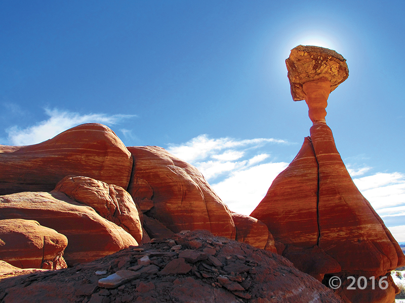
A hard cap rock protects the softer underlying pedestal and neck of this hoodoo in the Jurassic-age Entrada Sandstone, in the Toadstools area of Grand Staircase–Escalante National Monument, Kane County.
Photographer: Mark Milligan © 2016
![]()
The Utah Geological Survey (UGS) is a division of the Utah Department of Natural Resources. Several specialized programs comprise the UGS: Data Management, Energy & Minerals, Geologic Hazards, Geologic Information & Outreach, Geologic Mapping, Groundwater & Wetlands, and Paleontology.