Tag Archive for: MIllard County

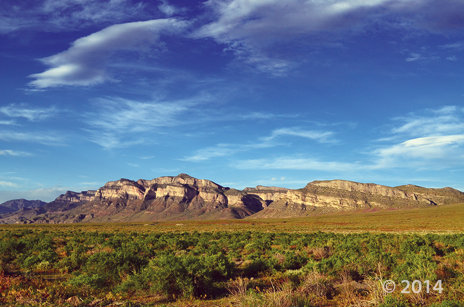
Gandy Salt Marsh, Millard County
Photographer: Rich Emerson © 2017
With the Deep Creek Mountains on the horizon, lush vegetation thrives in spring-fed wetlands that create an oasis in the middle of arid Snake Valley. Hundreds of springs and seeps in the valley provide habitat for many unique species of plants and animals.

Banded white marble and quartz augen (eyeshaped crystals) in gray argillite, Notch Peak, Millard County. Photographer: Mark Milligan; © 2014

POTD 6-16-15 Notch Peak Mineral Rock Argillite

Notch Peak, Millard County, Utah
Photographer: Mark Milligan; © 2014

Banded white marble and quartz augen (eyeshaped crystals) in gray argillite, Notch Peak, Millard County.

House Range, Millard County, Utah Photographer: J. Lucy Jordan; © 2014

POTD 2-17-15 House Range, Millard County

House Range, Millard County, Utah
Photographer: J. Lucy Jordan; © 2014

Where’s winter? On the upside, today feels a little like this photo—it is gorgeous out there. The mid-week peak is here with another weekend on the way. Who’s got outdoor adventures in their forecast??

By: Peter D. Rowley, Edward F. Rutledge, David J. Maxwell, Gary L. Dixon, and Chester A. Wallace

This 27-page report analyzes new detailed (1:12,000 scale) geologic mapping of a 14 square mile area centered by the high-temperature (350°F) Sulphurdale heat source, which at the surface makes up a circular area about a mile in diameter that is likely caused by a magma body at depth. A former small steam-driven geothermal electric power plant in the circular area is being replaced by a larger plant (Enel Green Power North America) that will use binary technology. Five cross sections tied to and at the same scale as the map help interpret the likely extent of the geothermal resource. Sulfur derived from evaporites at depth was initially mined at a solfatara above the heat source; associated sulfuric acid seeped downward to remove the Kaibab Limestone and Toroweap Formation from the subsurface.

GET IT HERE

We hope you’ve all had a great weekend! Here’s another stunning photo of Utah geology to start the week out.

Pahvant Butte, Millard County, Utah
Photographer: Mark Gwynn; © 2012

deseretnews.com

Geothermal power that came online in Utah and two other Western states helped keep the industry on the map in 2013 in what would have otherwise been a flat year domestically for new geothermal power production.

READ MORE

House Range, Juab and Millard Counties, Utah
Photographer: Jim Davis; © 2012

Swasey Mountain and the House Range, Juab and Millard Counties.

Chalk Knolls, Tule Valley, Millard County, Utah
Stefan Kirby

Stromatolites, precipitated by algae in reef-like columns, are common in the Cambrian-age Hellnmaria Member of the Notch Peak Formation, Chalk Knolls, Tule Valley, Millard County

Wah Wah Mountains, Millard County, Utah
Photographer: Tyler Knudsen

Nearly 1,000 feet of the Tunnel Spring Tuff, erupted from a nearby caldera about 35 million years ago, makes up Crystal Peak in the Wah Wah Mountains, Millard County.

Happy New Year, everyone!! Here’s a beautiful photo to start out the new year.

House Range, Millard County, Utah
Photographer: Tyler Knudsen

Sawtooth Mountain, which exhibits desert varnish and spheroidal weathering along joints, is a granitic intrusion in the House Range, Millard County.