Fremont petroglyphs
Photographer: Charles Bishop © 2017
At the mouth of Cottonwood Canyon, Fremont petroglyphs in the Northern San Rafael Style depict a hunting scene. The figures are etched into sandstone of the Green River Formation, and derive their contrast from the dark, weathered patina developed on the light-colored rock.
Tag Archive for: Green River Formation


eastern Uinta Basin, Uintah County, Utah
Photographer: Michael Vanden Berg; © 2014
Algal stromatolites from the Green River Formation, eastern Uinta Basin, Uintah County.

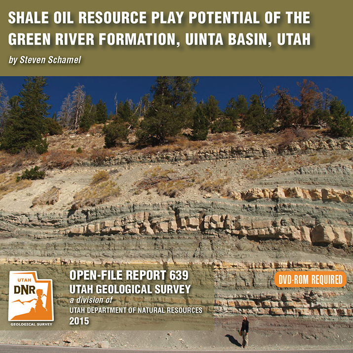
By: Steven Schamel
The Green River Formation in the Uinta Basin has may characteristics typical of an ideal shale oil resource play. It is a world-class oil-prone source rock. In nearly all parts of the basin there are many thousands of net feet of Type-l and Type-ll kerogen-rich calcareous mudstones, many intervals of which have average total organic carbon (TOC) of 5-10% or greater. In the north-central and western parts of the basin a substantial part of the formation is in the oil-generative window. Furthermore, organic maturation simulations done in this study using PRA BasinView-3D™ indicates early entry into the oil-generative window. In the northwest parts of the basin the lower Green River Formation was generating oil even before the end of the Eocene and slowing of sediment accumulation in the basin. The Green River Formation is unquestionably a superb petroleum system responsible for very large cumulative production of oil and associated natural gas, and an even larger potential oil sand resource. This DVD contains a 65-page report.

Hey friends, we’ve finally made way with our new website! Visit geology.utah.gov to see our new look. Though, as most technical endeavors, we’ve encountered some difficulties. Switching the URLs erased our subscription list, and those who subscribed to our “New Blog,” you will have to re-subscribe. We apologize for the inconvenience, but we hope you’ll forgive us when you see this pretty picture of Utah geology.
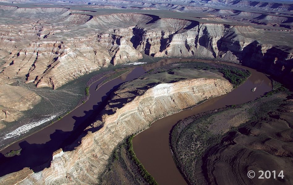
Desolation Canyon, Uintah County, Utah
Photographer: Adam Hiscock; © 2014
The Green River forms a dramatic “gooseneck” near Sand Wash in upper Desolation Canyon. The river has incised into rocks of the Douglas Creek and Parachute Creek Members of the Tertiary-age Green River Formation, which comprises sediments that accumulated in ancient Lake Uinta.
 Green River, Uintah County, Utah
Photographer: Stefan Kirby; ©2011
Morning light on layered rocks of the Tertiary-age Green River Formation north of Desolation Canyon along the Green River.
 Insect fossils in core retrieved from Green River Formation, Utah
Photographer: Michael Vanden Berg; © 2011
Insect fossils preserved in core retrieved from the lake-deposited Green River Formation.
 Uinta Basin, Uintah County, Utah
Photographer: Michael Vanden Berg
The Mahogany oil shale zone contains the highest percentage of organic material in the Green River Formation, Uinta Basin, Uintah County.
 Eastern Uinta Basin, Uintah County, Utah
Photographer: Michael Vanden Berg
Retrieving oil shale core from the Tertiary-age Green River Formation, eastern Uinta Basin, south of Bonanza near Evacuation Creek, Uintah County.
 INTERIM GEOLOGIC MAP OF THE EPHRAIM 7.5-MINUTE QUADRANGLE, SANPETE COUNTY, UTAH
Hellmut H. Doelling, Paul A. Kuehne, and Douglas A. Sprinkel
The Ephraim quadrangle is located about 140 miles south-southeast of Salt Lake City in Sanpete County in central Utah. A diagonal line, extending NE-SW across the quadrangle, divides Sanpete Valley to the northwest, from the Wasatch Plateau. Sanpete Valley is a structural feature in which the San Pitch River flows south along its west margin. Quaternary fans form a gently sloping surface from the plateau front to the floodplain of the river.
Bedrock units are mostly of early Tertiary age. These include the (ascending) North Horn Formation (1100+ feet thick), Flagstaff Limestone (500–1000 feet thick), Colton Formation (1400+ feet thick), Green River Formation (620+ feet exposed), and the Crazy Hollow Formation (less than 50 feet exposed). Of these, the North Horn Formation may also have some Late Cretaceous strata at the base. The older three units are exposed in the Wasatch Plateau, the other two along the plateau-valley margin.
35 p., 1 pl., scale 1:24,000
OFR-556……… $9.95
 Michael D. Vanden Berg, Utah Geological Survey
Presented at the AAPG Annual Conference, Denver, CO, June 2009
ABSTRACT
Due to the recent increase in crude oil prices and concerns over diminishing conventional reserves, the Utah Geological Survey has reexamined the Uinta Basin’s oil shale resource, primarily in the Mahogany zone of the Green River Formation. We created conversion equations by correlating available Fischer assays with corresponding density and sonic measurements as a way to predict oil yield from geophysical logs. In addition to the core-based Fischer assays obtained from 107 wells drilled specifically for oil shale, 186 oil and gas wells with oil yields calculated from digitized bulk density or sonic logs were used to create a basin-wide picture of the oil shale resource in the Uinta Basin. These widespread data were used to map oil shale thickness and richness and create isopach maps delineating oil yields of 15, 25, 35, and 50 gallons of shale oil per ton (GPT) of rock. From these isopach maps, new basin-wide resource numbers were calculated for each richness grade.
LEARN MORE ABOUT THE UTAH GEOLOGICAL SURVEY
![]()
The Utah Geological Survey (UGS) is a division of the Utah Department of Natural Resources. Several specialized programs comprise the UGS: Data Management, Energy & Minerals, Geologic Hazards, Geologic Information & Outreach, Geologic Mapping, Groundwater & Wetlands, and Paleontology.
QUICK LINKS
CONTACT INFORMATION
Staff Directory1594 West North Temple, Suite 3110
Salt Lake City, Utah 84116
801-537-3300 (phone)
801-537-3400 (fax)
Mailing Address:
PO BOX 146100
Salt Lake City, Utah 84114
HOURS
Monday through Friday,8 a.m. to 5 p.m.