 Jurassic-age Navajo Sandstone, Grand County, Utah
Photographer: Kent Brown
Arches in the making (alcoves) in massive cliffs of Jurassic-age Navajo Sandstone, near Moab, Grand County.
Jurassic-age Navajo Sandstone, Grand County, Utah
Photographer: Kent Brown
Arches in the making (alcoves) in massive cliffs of Jurassic-age Navajo Sandstone, near Moab, Grand County.
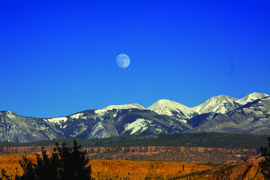
La Sal Mountains, Grand and San Juan Counties, Utah
Photographer: Jay Hill
The La Sal Mountains, near Moab in southeastern Utah, are laccoliths formed when upwelling magma intruded into and bulged the overlying sedimentary rock layers upward. The magma did not reach the surface, but subsequent erosion of the softer sedimentary rocks exposed the peak-forming igneous rocks that rise above the surrounding landscape.
 The Windows Section, Arches National Park, Grand County, Utah
Photographer: Nicholas Daniels
North Window Arch frames the distant landscape through a fin of the Jurassic-age Entrada Sandstone. The Windows Section, Arches National Park, Grand County.
 Near Moab, Grand County, Utah
Photographer: Carole McCalla
During Jurassic time, a sauropod walked across mud, sinking deeply into it. The footprints can be seen preserved in the rock near Moab in Grand County. BLM interpretive site.
 Poison Strip area, east of Arches National Park, Grand County, Utah
Photographer: Don DeBlieux
A geologist examines a sequence of Early Cretaceous-aged paleosols (ancient soils) in the Yellow Cat Member of the Cedar Mountain Formation. Many dinosaur fossils are found in these rocks, and the study of paleosols can provide valuable
information about the environments in which these dinosaurs lived.


Wall Arch, Arches National Park, Grand County, Utah
Photographers: Grant Willis (top)
and Rich Giraud (bottom)
Now you see it, now you don’t. Formerly located along the Devils Garden Trail in Arches National Park, Wall Arch collapsed sometime during the night of August 4th, 2008.

Arches National Park, Grand County, Utah
Photographer: Michael Vanden Berg
A small window in the Slick Rock Member of the Entrada Sandstone frames a view of Utah’s most famous landform, Delicate Arch. The arch is composed of Jurassic-aged sandstone including the Slick Rock Member (base and pedestals) and Moab Member of the Curtis Formation (bridge). In the distance, Oligocene-aged igneous rock forms the snow-covered La Sal Mountains.

Slickrock Trail near Moab, Grand County, Utah
Photographer: Jim Davis
Giant weathering pits or potholes like this one (about 16 feet across at the bottom) in the Jurassic-age Navajo Sandstone typically form along fractures and joints atop fins, knolls, and rounded domes. Potholes are created through a combination of physical, chemical, and biological processes that weather and erode the rock and are home to a remarkable array of ancient aquatic organisms.

Crystal Geyser, Green River, Grand County, Utah.
Photographer: Taylor Boden
Colorful travertine (calcium carbonate) is deposited around cold-water, carbon-dioxide-driven Crystal Geyser.

East of the Green River, Grand County, Utah.
Photographer: Don DeBlieux
A summer evening arrives with the promise of cooler temperatures at the UGS paleontology camp near the Crystal Geyser Dinosaur Quarry.

The Utah Geological Survey (UGS) is a division of the Utah Department of Natural Resources. Several specialized programs comprise the UGS: Data Management, Energy & Minerals, Geologic Hazards, Geologic Information & Outreach, Geologic Mapping, Groundwater & Wetlands, and Paleontology.
1594 West North Temple, Suite 3110
Salt Lake City, Utah 84116
801-537-3300 (phone)
801-537-3400 (fax)
Mailing Address:
PO BOX 146100
Salt Lake City, Utah 84114
Monday through Friday,
8 a.m. to 5 p.m.
![]()