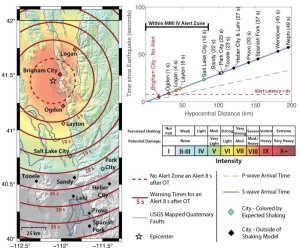
Warning time scenario if a magnitude 7 (M7) earthquake occurred on the Brigham City segment of the Wasatch fault zone. The red circles show how much warning time would be provided at that location before shaking begins. The dashed red circle is the “no-alert zone” for an alert latency of eight seconds. Colors indicate the maximum intensity of expected shaking caused by “shear wave” energy created by the earthquake. OT = origin time. From Bowman et al., 2023, On the feasibility of implementing an earthquake early warning (EEW) system in Utah: Online, doi.org/10.34191/EEW-2023
POPULAR POSTS & PAGES
LEARN MORE ABOUT THE UTAH GEOLOGICAL SURVEY

The Utah Geological Survey (UGS) is a division of the Utah Department of Natural Resources. Several specialized programs comprise the UGS: Data Management, Energy & Minerals, Geologic Hazards, Geologic Information & Outreach, Geologic Mapping, Groundwater & Wetlands, and Paleontology.
QUICK LINKS
CONTACT INFORMATION
1594 West North Temple, Suite 3110
Salt Lake City, Utah 84116
801-537-3300 (phone)
801-537-3400 (fax)
Mailing Address:
PO BOX 146100
Salt Lake City, Utah 84114


