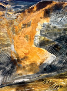
The Manefay landslide at the Bingham Canyon openpit copper mine on April 11, 2013. This view, toward the northeast, shows the landslide in its entirety with the main failure plane angling downward from the right side of the headwall scarp toward the buildings in the middle left. The slip plane is in the Manefay series beds of the Bingham Mine Formation. Also notable are the two different slides—the earlier lightgray slide of pyritized Bingham Mine Formation quartz sandstones overlain by the yellow-brown, oxidized dump material which slid about 1.5 hours later. Also apparent is the fluidity of the slide as shown by the layering in the foot of the deposit in the pit bottom. Multiple pieces of mining equipment caught up in the slide are barely visible at the toe of the slide in the lower left. Photo courtesy of Kennecott Utah Copper.
POPULAR POSTS & PAGES
LEARN MORE ABOUT THE UTAH GEOLOGICAL SURVEY

The Utah Geological Survey (UGS) is a division of the Utah Department of Natural Resources. Several specialized programs comprise the UGS: Data Management, Energy & Minerals, Geologic Hazards, Geologic Information & Outreach, Geologic Mapping, Groundwater & Wetlands, and Paleontology.
QUICK LINKS
CONTACT INFORMATION
1594 West North Temple, Suite 3110
Salt Lake City, Utah 84116
801-537-3300 (phone)
801-537-3400 (fax)
Mailing Address:
PO BOX 146100
Salt Lake City, Utah 84114


