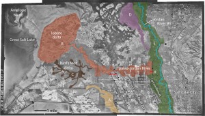
Mosaic of 1953 Army Map Service black and white aerial photographs of Great Salt Lake, Salt Lake City, and the southern tip of Antelope Island. Highlighted areas show a simplified representation of post-Lake Bonneville river channels and deltaic deposits. A) Gilbert-episode river channel and delta deposited as the lake receded, B) post-Gilbert, west-flowing paleo-Jordan River and associated lobate delta, C) bird’s foot delta that was likely deposited during the late Holocene highstand of Great Salt Lake, D) delta deposited during northward flow of the Jordan River, E) approximate location of Jordan River meander floodplain, F) modern modified channel of the Jordan River, G) location of 2010 paleoseismic trench on the Granger fault, H) location of 1997 and 2015 paleoseismic trenches on the Taylorsville fault.
POPULAR POSTS & PAGES
LEARN MORE ABOUT THE UTAH GEOLOGICAL SURVEY

The Utah Geological Survey (UGS) is a division of the Utah Department of Natural Resources. Several specialized programs comprise the UGS: Data Management, Energy & Minerals, Geologic Hazards, Geologic Information & Outreach, Geologic Mapping, Groundwater & Wetlands, and Paleontology.
QUICK LINKS
CONTACT INFORMATION
1594 West North Temple, Suite 3110
Salt Lake City, Utah 84116
801-537-3300 (phone)
801-537-3400 (fax)
Mailing Address:
PO BOX 146100
Salt Lake City, Utah 84114


Leave a Reply
Want to join the discussion?Feel free to contribute!