Tag Archive for: Uinta Basin

 © Michael Vanden Berg
Uinta Basin Photomicrograph. Photo by Michael Vanden Berg.
Photomicrograph of limestone from the Eocene-age Green River Formation showing small ostracod shells surrounding and filling larger
gastropod fossils.


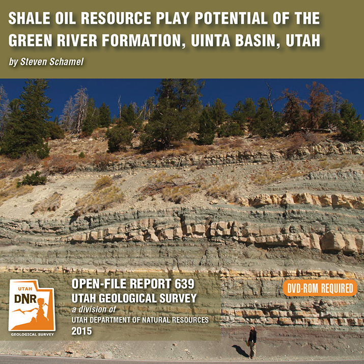
By: Steven Schamel
The Green River Formation in the Uinta Basin has may characteristics typical of an ideal shale oil resource play. It is a world-class oil-prone source rock. In nearly all parts of the basin there are many thousands of net feet of Type-l and Type-ll kerogen-rich calcareous mudstones, many intervals of which have average total organic carbon (TOC) of 5-10% or greater. In the north-central and western parts of the basin a substantial part of the formation is in the oil-generative window. Furthermore, organic maturation simulations done in this study using PRA BasinView-3D™ indicates early entry into the oil-generative window. In the northwest parts of the basin the lower Green River Formation was generating oil even before the end of the Eocene and slowing of sediment accumulation in the basin. The Green River Formation is unquestionably a superb petroleum system responsible for very large cumulative production of oil and associated natural gas, and an even larger potential oil sand resource. This DVD contains a 65-page report.
 Uinta Basin, Uintah County, Utah
Photographer: Michael Vanden Berg
The Mahogany oil shale zone contains the highest percentage of organic material in the Green River Formation, Uinta Basin, Uintah County.
 Eastern Uinta Basin, Uintah County, Utah
Photographer: Michael Vanden Berg
Retrieving oil shale core from the Tertiary-age Green River Formation, eastern Uinta Basin, south of Bonanza near Evacuation Creek, Uintah County.
 Uinta Basin, Uintah County, Utah
Photographer: Michael Vanden Berg
The exceedingly rare Graham’s penstemon grows exclusively on the sparsely vegetated outcrops of Green River Formation oil shale deposits and can be found only in the Uinta Basin of Utah and the Piceance Creek Basin in Colorado. Federal protection for this scarce plant could be forthcoming as petroleum development becomes more prevalent in the basin.
 Fantasy Canyon, Uinta Basin, Uintah County, Utah
Photographer: Jim Davis
A sandstone layer within the Eocene-aged Uinta Formation forms a surreal landscape at Fantasy Canyon. Sandwiched between more easily erodible layers of claystone and mudstone, the exposed sandstone has weathered into an intricate rock garden containing over twenty named sculptures, including “Alien Head” in the foreground.
deseretnews.com
An Estonia company that claims it has perfected turning oil shale into fuel oil during the past 30 years wants to mine rock from a remote region of the Uintah Basin, tapping 2.6 billion barrels of oil in the decades to come.
That staggering production, 50,000 barrels of oil per day, would represent one-third of Utah’s liquid fuel consumption and is touted to emerge from a processing and refining plant that would put power back into the energy grid.
READ MORE
aapg.org
Geologic intervals that may have looked a bit ho-hum when pierced by the drill bit on its way to the Real Target can, on second look, yield some pleasant surprises.
The Uteland Butte Member of the Eocene Green River Formation in the Uinta Basin in Utah is one of these.
It’s the basal member of the Green River, above the Upper Paleocene to Lower Eocene Wasatch Formation, which is predominantly a sandstone with red, green and gray shales deposited in a fluvial setting.
In contrast, the Uteland Butte is indicative of a lacustrine environment and is mainly limestone, dolomite, organic rich calcareous mudstone and siltstone, with some thin sandstones, according to AAPG member Michael Vanden Berg.
Cretaceous Mancos Shale, Uinta Basin, Utah
A research team from the Utah Geological Survey and the University of Utah presented the results of their on-going work in the Uinta Basin to members of the petroleum industry recently. Meeting in Denver on June 28, the UGS and university geologists discussed their research on the oil and gas potential of the Cretaceous Mancos Shale, which lies several thousand feet below the surface in most of the Basin. Although oil and gas from shale have made energy headlines in many states, production from the Mancos will be a challenge, due in part to its thickness compared to other U.S. shale plays. About 20 geologists and engineers representing 10 companies with interests in the Uinta Basin attended the meeting. The research is being funded by the Research Partnership to Secure Energy for America, through a contract from the U.S. Department of Energy.
See http://geology.utah.gov/emp/shalegas/cret_shalegas/index.htm for more information about the project.
Tag Archive for: Uinta Basin
Uinta Basin Photomicrograph. Photo by Michael Vanden Berg.
Photomicrograph of limestone from the Eocene-age Green River Formation showing small ostracod shells surrounding and filling larger
gastropod fossils.
By: Steven Schamel
The Green River Formation in the Uinta Basin has may characteristics typical of an ideal shale oil resource play. It is a world-class oil-prone source rock. In nearly all parts of the basin there are many thousands of net feet of Type-l and Type-ll kerogen-rich calcareous mudstones, many intervals of which have average total organic carbon (TOC) of 5-10% or greater. In the north-central and western parts of the basin a substantial part of the formation is in the oil-generative window. Furthermore, organic maturation simulations done in this study using PRA BasinView-3D™ indicates early entry into the oil-generative window. In the northwest parts of the basin the lower Green River Formation was generating oil even before the end of the Eocene and slowing of sediment accumulation in the basin. The Green River Formation is unquestionably a superb petroleum system responsible for very large cumulative production of oil and associated natural gas, and an even larger potential oil sand resource. This DVD contains a 65-page report.
Uinta Basin, Uintah County, Utah
Photographer: Michael Vanden Berg
The Mahogany oil shale zone contains the highest percentage of organic material in the Green River Formation, Uinta Basin, Uintah County.
Eastern Uinta Basin, Uintah County, Utah
Photographer: Michael Vanden Berg
Retrieving oil shale core from the Tertiary-age Green River Formation, eastern Uinta Basin, south of Bonanza near Evacuation Creek, Uintah County.
Uinta Basin, Uintah County, Utah
Photographer: Michael Vanden Berg
The exceedingly rare Graham’s penstemon grows exclusively on the sparsely vegetated outcrops of Green River Formation oil shale deposits and can be found only in the Uinta Basin of Utah and the Piceance Creek Basin in Colorado. Federal protection for this scarce plant could be forthcoming as petroleum development becomes more prevalent in the basin.
Fantasy Canyon, Uinta Basin, Uintah County, Utah
Photographer: Jim Davis
A sandstone layer within the Eocene-aged Uinta Formation forms a surreal landscape at Fantasy Canyon. Sandwiched between more easily erodible layers of claystone and mudstone, the exposed sandstone has weathered into an intricate rock garden containing over twenty named sculptures, including “Alien Head” in the foreground.
deseretnews.com
An Estonia company that claims it has perfected turning oil shale into fuel oil during the past 30 years wants to mine rock from a remote region of the Uintah Basin, tapping 2.6 billion barrels of oil in the decades to come.
That staggering production, 50,000 barrels of oil per day, would represent one-third of Utah’s liquid fuel consumption and is touted to emerge from a processing and refining plant that would put power back into the energy grid.
READ MORE
aapg.org
Geologic intervals that may have looked a bit ho-hum when pierced by the drill bit on its way to the Real Target can, on second look, yield some pleasant surprises.
The Uteland Butte Member of the Eocene Green River Formation in the Uinta Basin in Utah is one of these.
It’s the basal member of the Green River, above the Upper Paleocene to Lower Eocene Wasatch Formation, which is predominantly a sandstone with red, green and gray shales deposited in a fluvial setting.
In contrast, the Uteland Butte is indicative of a lacustrine environment and is mainly limestone, dolomite, organic rich calcareous mudstone and siltstone, with some thin sandstones, according to AAPG member Michael Vanden Berg.
Cretaceous Mancos Shale, Uinta Basin, Utah
A research team from the Utah Geological Survey and the University of Utah presented the results of their on-going work in the Uinta Basin to members of the petroleum industry recently. Meeting in Denver on June 28, the UGS and university geologists discussed their research on the oil and gas potential of the Cretaceous Mancos Shale, which lies several thousand feet below the surface in most of the Basin. Although oil and gas from shale have made energy headlines in many states, production from the Mancos will be a challenge, due in part to its thickness compared to other U.S. shale plays. About 20 geologists and engineers representing 10 companies with interests in the Uinta Basin attended the meeting. The research is being funded by the Research Partnership to Secure Energy for America, through a contract from the U.S. Department of Energy.
See http://geology.utah.gov/emp/shalegas/cret_shalegas/index.htm for more information about the project.
LEARN MORE ABOUT THE UTAH GEOLOGICAL SURVEY

The Utah Geological Survey (UGS) is a division of the Utah Department of Natural Resources. Several specialized programs comprise the UGS: Data Management, Energy & Minerals, Geologic Hazards, Geologic Information & Outreach, Geologic Mapping, Groundwater & Wetlands, and Paleontology.