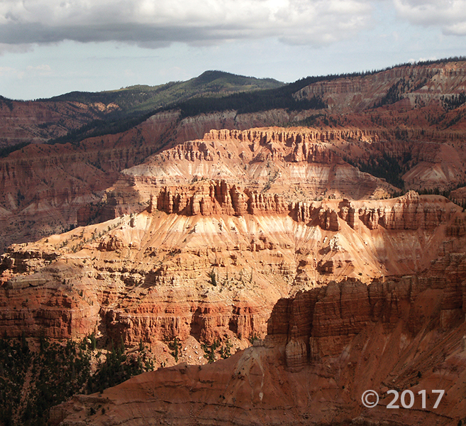
Cedar Breaks National Monument, Iron County
Photographer: Ken Krahulec © 2017
Headward erosion into the Markagunt Plateau has created the spectacular badlands of the Cedar Breaks amphitheater. The brightly colored rocks of the Claron Formation include limestone, mudstones, sandstone, and conglomerate deposited in streams and lakes around 50 million years ago, as well as ancient soils developed in these deposits.
Tag Archive for: Iron County
kutv.com
CEDAR CITY, Utah — (AP) The University of Utah Seismograph Stations has reported a minor earthquake in the southwestern part of the state.

View from Brian Head peak, Iron County
Photographer: Paul Inkenbrandt © 2016
Markagunt Plateau, Iron County
Photographer: Tyler Knudsen © 2016

An unnamed lake fills one of countless sinkholes formed on southern Utah’s Markagunt Plateau. Dark boulders of Quaternary-age lava have collapsed into the sinkhole that is likely rooted in limestone of the underlying Tertiary-age Claron Formation.
They say practice makes perfect, and on the subject of earthquakes in Utah, it’d be wise to plan ahead. Have you discussed your plan with friends and family in the event of a large earthquake? Do you have an emergency kit made up? The Southwest Utah Public Health Department, along with several partner agencies, will be holding an earthquake drill on March 17, 2016 throughout southwest Utah. Find more information in the article on how you can participate and help preparedness efforts.
ironcountytoday.com
Whether we realize it or not, Southern Utah is earthquake country. There have been numerous small earthquakes in this area in recent years and, according to the USGS (United States Geological Survey), they provide a good reminder that people in Utah and Northern Arizona should be prepared.
For more earthquake preparedness information, visit http://www.utah.gov/beready/index.html.
sltrib.com
In a community struggling with a depleted aquifer and land subsidence, the Central Iron County Water Conservancy District is banking on a 50-mile, $150 million pipeline to ease the area’s water shortage.
Bill Lund, one of our senior scientists here at the Utah Geological Survey, weighs in on the issues surrounding groundwater mining and its effects in Iron County.
kuer.org
We can’t see aquifers, but these underground water reservoirs make life possible in the West. As we continue our series on Utah’s Uncertain Water Future, we explore the consequences of mining groundwater in Utah’s Cedar Valley.
Here’s a read covering the issues in Iron County surrounding the declining underground water levels, and its effects up above.
ironcountytoday.com
Since at least the 1960s, more water has been removed from Cedar Valley’s underground water supply than has been replenished, and that problem is only getting worse.
 By: Robert F. Biek, John J. Anderson, Edward G. Sable, and Peter D. Rowley
The Panguitch Lake quadrangle lies in the central part of the Markagunt Plateau in southwest Utah and includes Panguitch Lake, a popular area of summer and winter recreational use. Despite the plateau’s relatively simple structure of a gently east-tilted fault block, the quadrangle contains scenic and instructive exposures of southwest Utah’s youngest basaltic lava flows, classic examples of inverted valleys capped by older lava flows, glacial deposits in the Castle Valley area, and the southern margin of the Markagunt Megabreccia. The Megabreccia is the debris of Utah’s largest catastrophic landslide deposit, which covers 1300 square miles (3400 km²) of the northern and central Markagunt Plateau.
thespectrum.com
The third annual Iron County Emergency Preparedness Expo will focus its efforts on teaching children how to handle disasters as it provides information regarding various emergencies to the entire community at Cedar High School on Saturday.


