
Commonly Asked Questions About Utah’s Great Salt Lake & Lake Bonneville
Public Information Series #39, By J. Wallace Gwynn, 1996 and
Public Information Series #104, By Jim Davis, J. Wallace Gwynn, and Andrew Rupke, 2022
Great Salt Lake is true to its name—historically, economically, geologically, and biologically the lake abounds with superlatives. The largest lake in North America without an outlet to the ocean expands and contracts, nearly doubling in depth and more than tripling in area at times since lake elevation has been recorded. Its salinity changes seasonally and annually, salt concentrations are typically several times that of the ocean, and parts of the lake sometimes reach salt saturation. Humans have fragmented the lake with dikes and causeways, and these fragments vary in chemistry and biology, giving the lake a mosaic of different salinities, colors, and organisms.

Scroll down to learn more about Great Salt Lake and Lake Bonneville, or select a topic to jump to a specific section.
LAKE BONNEVILLE
What was Lake Bonneville?

Outline of Lake Bonneville at the Bonneville shoreline around 18,000 years ago, and modern remnant lakes and features.
Lake Bonneville was a gigantic, freshwater Ice Age lake that rose beginning some 30,000 years ago to wholly fill the Bonneville basin of the eastern Great Basin. At its maximum extent 18,000 years ago, it was 20,000 square miles in area and more than a thousand feet deep, covering much of western Utah and extending into Idaho and Nevada. Because it occupied part of the Basin and Range physiographic province, typified by a pattern of long mountain ranges and adjacent valleys, Lake Bonneville had a highly irregular coastline with many islands and peninsulas great and small. Lake Bonneville measured about 325 miles long north to south and 135 miles wide west to east—at the time the largest lake in the Western Hemisphere. By 13,000 years ago Lake Bonneville had all but vanished, setting the stage for its successor, Great Salt Lake.
Why did Lake Bonneville form?
Earth is currently in an Ice Age. Much of the last 3 million years has had substantially colder temperatures relative to most of geologic time, with episodes of expansive continental and alpine glaciation. These cold episodes of the Ice Age are called “glacials.” Glacials are interrupted by briefer timespans within the Ice Age of more mild temperatures and retreating glaciers called “interglacials,” such as the one beginning more than 14,000 years ago that continues today. During the last glacial episode, the climate was cooler and wetter in Utah and summers were mild. The input of water into the Bonneville basin exceeded the output by evaporation beginning about 30,000 years ago. Twelve thousand years later the lake had risen to the elevation of the Bonneville shoreline, with glacial extent in the Wasatch Range reaching a maximum 3,000 years before.
Prior glacial episodes had caused other large lakes to form in the Bonneville basin—four massive freshwater lakes in the last 780,000 years—but the last glacial episode likely generated the largest lake and the only lake to overtop the basin threshold and drain to the ocean (see “Where did Lake Bonneville go?”). The larger dimensions of Lake Bonneville occurred in the last glacial episode chiefly because of the diversion of the upper Bear River some 55,000 years ago by lava flows west of Soda Springs, Idaho, that substantially increased the amount of water entering the Bonneville basin.
Where did Lake Bonneville go?
,")
Rise and fall of Lake Bonneville. Modified from C.G. Oviatt (2020), “G.K. Gilbert and the Bonneville Shoreline.”
Around 18,000 years ago, Lake Bonneville had risen to the brim of its basin at Red Rock Pass in southeastern Idaho and began spilling out to the Pacific Ocean via the Snake and Columbia Rivers. At Red Rock Pass, the natural dam of alluvial sediments holding back the lake either was quickly downcut by being overtopped by the lake or the dam of sediments catastrophically failed, initiating the colossal Bonneville flood. The floodwater volume has been estimated at around 1,100 cubic miles (more than 1.2 quadrillion gallons), comparable to the volume of water in Lake Michigan. Within weeks to months after the breach, the lake lowered around 425 feet until a new, lower threshold was established. Over the centuries the threshold rose as landslides and gigantic blocks of bedrock at Red Rock Pass relentlessly plunged into the lake’s outlet. The lake drained to the Pacific Ocean for some 1,000 to 3,000 years and created a prominent “Provo” shoreline below the Bonneville shoreline. As the climate warmed the lake contracted and eventually reached the level of modern Great Salt Lake by 13,000 years ago.
What are those terraces on the mountains?
Terraces in the Bonneville basin mark various levels of Lake Bonneville when erosional and depositional processes were sufficient to leave a physical expression of the lake’s shoreline. These notches or steps on the landscape are pronounced where the slopes were exposed to strong wave action, where depositional shoreline features grew by sediment accumulation in the lake such as spits and bars formed from currents, or where canyon streams emptied into the lake, dropping their sediment loads and forming deltas. The Provo level—the lake level after the Bonneville flood that remained stable for a thousand years or longer—created broad deltas that extend out into the valleys from major streams of the Wasatch Range. Many of these deltas and other shoreline features are mined for their well-sorted, rounded sand and gravel. The 100-mile-long Bonneville Shoreline Trail along the Wasatch Front follows the terrace of the Bonneville shoreline. The Utah State Capitol sits just above the oldest prominent terrace, the Stansbury shoreline, formed some 7,000 years before the Bonneville shoreline.
The shorelines give a close estimation of past lake elevation. However, the shorelines are uplifted to varying degrees from isostatic rebound, or crustal readjustment, after the removal of the weight of Lake Bonneville, particularly toward the center of the lake basin. At the Lakeside Mountains on the west side of Great Salt Lake, near the center of the Bonneville basin, the Bonneville shoreline now stands more than 240 feet higher than the Bonneville shoreline around the perimeter of the basin. Near Salt Lake City, shorelines are about 100 feet higher in elevation. When the elevations of these shorelines were mapped by pioneering geologist G.K. Gilbert and his team (USGS Monograph 1, Lake Bonneville, 1890), he recognized that “. . . the area of maximum uplift coincides with the center of the principal area of deep water. . .” Gilbert wrote that Earth’s crust could be deformed by adding weight to it, and that underneath the crust must be material that deforms plastically to accommodate this deformation, like “. . . a bowl of jelly upon which a coin has been laid.”


. Photo by David Shearer, Great Salt Lake Harbormaster.")
GREAT SALT LAKE BASICS
What is the origin of Great Salt Lake?
By 14,000 years ago this region became warmer and drier, increasing evaporation rates, dropping Lake Bonneville below its threshold and once again confining the lake to its internally drained closed basin where it has remained since. Over the next thousand years the lake level had lowered to approximately the level of Great Salt Lake today—a miniature relic of a once-vast Ice Age lake.
Great Salt Lake is situated in the eastern part of the Great Basin, a hydrologically closed basin—no rivers leave its boundaries—that contains many discrete, closed basins. The Great Basin hydrological province is in the northern and western part of the much larger Basin and Range physiographic province. Stretching and rising of Earth’s crust from tectonic forces and heat at great depth has caused the Basin and Range region to extend, thin, and fracture. Defining the Basin and Range Province is the pattern of north-south-trending, fault-bounded mountain ranges and adjacent valleys and common geographic features such as hot springs, playas, alluvial fans, and geologically recent basalt flows.
Where does Great Salt Lake get its water?
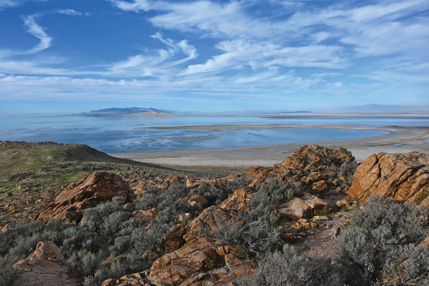
View of Bridger Bay atop blocky Tintic Quartzite at Buffalo Point, Antelope Island. Photo by Christian Hardwick
Runoff from the Uinta Mountains and the Wasatch Range supplies most water to the lake. The Bear, Weber, and Jordan Rivers empty into the eastern part of Great Salt Lake and supply around 70 percent of the water input into the lake. The Bear River alone supplies nearly 40 percent of all the lake’s water. The remainder is direct precipitation on the lake surface, at around 30 percent, and a small percentage of water enters the lake as groundwater and from intermittent streams of the West Desert. Because fresh water from rivers enters the eastern side of the lake, and because of dikes and artificial impoundments, hundreds of square miles of fresh and brackish wetlands comprise this fragmented eastern edge. The average annual water input into the lake is around 3.6 million acre-feet (5.8 billion cubic yards). Since 1847, annual water input has varied from as low as one million acre-feet (1.6 billion cubic yards) to as high as 9 million acre-feet (14.5 billion cubic yards).
How big and deep is the lake?

Areal extent and elevation of Great Salt Lake at historical high, average, and historical low-water levels.
Since measurements began in 1847, the lake level has fluctuated more than 22 feet from a high of 4,211.6 feet above mean sea level in 1986–87, and a similarly high level in 1872–74, to a low of 4,190.2 feet in October of 2021, smashing the previous 1963 record low of 4,191.4 feet. The 2021 record was broken again less than a year later in July 2022. The average elevation of the lake is around 4,200 feet, a level not attained since 2001. At 4,200 feet Great Salt Lake is 75 miles long by 35 miles wide and covers about 1,600 square miles with a maximum depth of 33 feet. Lake level typically drops 1.5 to 2.5 feet annually, dipping to its lowest level September to December. More variable is the lake’s rise, peaking from March to July following the melting of mountain snowpack. The largest seasonal rises have been in the early 1980s and in 2011 when the lake rose nearly 5 feet, but in some years it has risen less than a foot.
Great Salt Lake changes significantly in area because it is a closed-basin lake. In particular, the lake occupies an extremely flat lakebed, interrupted by long, tall mountain ranges. In just one season stretches of the shoreline can advance or retreat thousands of feet. For every one-foot increase or decrease in lake level, about 70 square miles of lakebed is inundated or exposed. To reach water that is deep enough to swim in, one usually needs to wade out far from the beach.
How many islands are in Great Salt Lake?
Great Salt Lake has many islands, big and small, due to the mountain and valley pattern of the Basin and Range Province. The total number of islands—land surrounded by water—depends on lake level, with more islands as lake level rises and zero islands when the lake is at its lowest levels. In the greater Great Salt Lake system, encompassing Farmington Bay and Bear River Bay, there are 14 official places with “island” in the name.
The four largest islands are Antelope (~42 square miles [sq. mi.]), Stansbury (~35 sq. mi.), Fremont (~5 sq. mi.), and Carrington (~2.5 sq. mi.). Nearly all of Antelope Island is a state park accessed via the Antelope Island Causeway in Davis County. One can also drive to Stansbury Island, a few miles north of Interstate 80. Both islands rise more than 2,000 feet above the lake surface. Fremont Island, recently placed in a conservation easement held by The Nature Conservancy and donated to the State of Utah, is now for the first time accessible to the public, non-motorized vehicles only. Gunnison Island, in the north arm, is home to an American white pelican breeding colony. Because of the sensitive nesting areas, Gunnison Island is a State Wildlife Management Area and closed to the public, as is its tiny satellite Cub Island. The small Hat Island, north of Carrington Island, is also a State Wildlife Management Area for nesting California gulls and herons and is closed to the public. White Rock and Egg Island, off the coast of Antelope Island, are closed to protect rookeries from April 1 to July 31. The islands allow for birds to nest without the threat of predation, although lake levels drop low enough some years to connect to the mainland.
. UGS file photo, June 1982.")
 and Cub (foreground) Islands, June 2015. These islands can be three, two, or one island depending on lake level, or connected to the mainland at low lake levels (about 4,195 feet). Photo courtesy of the Utah Division of Wildlife Resources.")
 connects to Gilbert Bay (south arm) at 4,205 feet elevation. UGS file photo, September 30, 1988")
 of Fremont Island and nearby Promontory Mountains, a peninsula in Great Salt Lake. Fremont Island (named after John C. Frémont) has also been called Disappointment Island, Castle Island, and Miller’s Island. Photo by Donald Rusk Currey, University of Utah.")
Why is the lake two colors?
The clear contrast in color between the blue-green south arm and the red-violet north arm is a result of different salinities caused by the rockfill causeway constructed in 1959. The causeway is a mostly impermeable barrier to the exchange of water between the north and south arms, although exchange was enhanced by the mid-lake breach in 2016. Most fresh water entering the lake empties into the south arm. Conversely, the isolated north arm only receives about 10 percent of all freshwater input into Great Salt Lake. So, the amount of water evaporated far exceeds that of fresh water entering the north arm. The outcome is highly saline or salt-saturated water. The north arm’s high salinity has excluded most aquatic life that existed prior to the rock-fill causeway. Nevertheless, hundreds of species of archaea, bacteria, and algae with pigmentation contribute to the color of the north arm of the lake with the precise color at any one time determined by the assemblage of species present. Organisms that thrive in the extremely salty water are Haloarchaea species, some of which contain a purple-reddish protein called bacteriorhodopsin. Millions of these organisms can occupy a single drop of water. Other halophiles, or “salt-lovers,” include the highly salt-tolerant green alga Dunaliella salina that also colors the water due to its red-orange carotenoids—pigments that protect chlorophyll in algae and plants from damage from intense solar radiation. Evaporation ponds fringing the lake turn a vibrant red color when salinity is high due to these microorganisms. The south arm, which has a much lower salinity than the north arm, harbors a different assemblage of organisms and typically takes on a bluish-green color from organisms such as Dunaliella viridis, a green alga that is a staple food for brine shrimp.
 to the Lakeside Mountains (upper right). The causeway creates a hydrologic separation causing differing water chemistry between the north and south arms. The colors are caused by distinct microbial assemblages.")
 becomes highly saline to salt saturated and microscopic organisms color the lake rose red. Lightcolored areas of the Great Salt Lake Desert, the dried-up West Desert Pond, and Bonneville Salt Flats on left side of photo. Utah Lake at lower right.")
What is that smell?

White-faced ibis wade in the shallows of the lake’s eastern wetlands adjacent to the populous Wasatch Front urban corridor. Downtown Salt Lake City and the Wasatch Range in the distance. Photo courtesy of the Utah Division of Wildlife Resources
“Lake stink” is the first thing that comes to mind for many Utahns when considering Great Salt Lake. Often with the passage of storms the smell makes its way to Salt Lake City and the Wasatch Front. The smell is due to hydrogen sulfide gas, which has a “rotten egg” odor and is a product of biological productivity in oxygen-free environments. The gas is largely emanating from Farmington Bay, the closest part of the lake to much of the Wasatch Front. A contributing factor is partially treated agricultural, industrial, and municipal runoff that adds nutrients to the bay. Additionally, a “salt wedge” of high-density saline water from Gilbert Bay becomes established along the bottom of Farmington Bay, stratifying the bay with fresh water on top and a salty layer below, trapping organic material. A surge of nutrients spurs algal blooms that use up available oxygen, boosting anaerobic bacteria—bacteria that live and grow in oxygen-free environments—that feed on the organic material and produce hydrogen sulfide. This same process, creating the same smell, occurs in tidal flats, swamps, and estuaries around the world. Due to the shallowness of the lake, strong winds can overturn the water and release the gas from the bottom layers and sediments. Captain Howard Stansbury, writing about lake stink in 1850 on the muddy flats west of Ogden City, noted that the area “. . . seemed to be impregnated with all the villainous smells which nature’s laboratory was capable of producing.” Even without the byproducts of bacterial activity in the lake, various smells are also produced from an accumulation of organic material, including decomposing brine fly pupae casings that accumulate in drifts along the beach.
Who owns the lake?
Multiple public and private agencies, companies, organizations, individuals, and municipalities own lands and wetlands around the lake, and the islands within the lake. In 1976, the U.S. Supreme Court ruled that the state owns all the lands, brines, and other minerals within the bed and waters of the lake and all shore lands located within the officially surveyed meander line. The “meander line” falls within an elevation range of 4,202 to 4,212 feet above sea level. This land is under the title of State Sovereign Land, or Trust Lands, meaning that the State of Utah holds these lands and their resources in trust for the use and enjoyment of the public under the management of the Utah Division of Forestry, Fire and State Lands.
Great Salt Lake Fundamentals
| Lake Type | Tectonic; crustal extension |
|---|---|
| Basin Type | Closed-basin (Endorheic) |
| Area* | 1,600 square miles |
| Length* | 75 miles |
| Width* | 35 miles |
| Maximum Depth* | 33 feet |
| Average Depth* | 14 feet |
| Watershed | 21,500 square miles |
| Volume* | 25 billion cubic yards (4.55 cubic miles) |
| Salinity Range | 5% to 29% |
| Annual Evaporation* | 4.7 billion cubic yards (0.86 cubic miles) |
| Water Temperature Range | 22°F to 89°F |
GEOLOGY
Why is the lake salty?
High salt concentrations are a result of the lake not having an outlet. Great Salt Lake occupies a topographical bowl with no stream exiting the lake and therefore does not have a way of expelling any salts that enter the lake. Each year several million tons of dissolved salts are added to Great Salt Lake from its tributary rivers. Evaporation is the only way water leaves the lake—on average the lake loses billions of gallons of water a day to the atmosphere. As the water evaporates the salt-forming minerals are left behind, concentrating over time. For Great Salt Lake these minerals are composed mostly of sodium and chloride (i.e., NaCl [common salt]), similar in ratio to the ocean but typically several times greater in quantity.
Like other closed-basin lakes (known as endorheic lakes) of the Great Basin and lakes in arid regions around the world, Great Salt Lake has a high and variable concentration of dissolved solids due to its drastically changing volume. Lake volume at any given time is a function of the weather in its basin. The melting of heavy snowpack in the mountains can cause large rises in lake elevation during the springtime, diluting the salinity, and persistent droughts will drop the lake level year after year, concentrating salts.
How much salt is in Great Salt Lake and why does that change?

The salt-saturated north arm of Great Salt Lake produces pink water and white salt-encrusted rocks. Photo taken from Gunnison Island. Cub Island, which can be two separate islands at certain lake elevations, is in the background. Photo courtesy of the Utah Division of Wildlife Resources, July 2015.
The total amount of salt dissolved in Great Salt Lake is estimated to be nearly 5 billion tons. Several million tons of dissolved solids are added to the lake each year from streams. Extractive industries remove about 3 million tons of minerals a year. Salinity differs between the north side of the lake (north arm) and the larger, river-fed south side (south arm) since the construction of a rock-fill railroad causeway in 1959 that replaced the wooden trestle (see “Why was a railroad built across Great Salt Lake”). In 2020, the south arm had a salinity between 12 and 16 percent and the north arm between 27 and 29 percent. As the lake rises, salinity drops because the same amount of salt is diluted by more fresh water. Conversely, as the lake lowers, the lake becomes saltier. The south arm of the lake can also become stratified, having a deeper, heavy brine layer at the bottom of the lake and less-saline water on top. This stratification occurred after the construction of the rock-fill railroad causeway. Dividing the lake set up a north-south water exchange, where less saline south arm brine flows north above heavier brine of the north arm that flows south through openings in the causeway.
What are the white, round sand grains on the beaches?

A magnified photo of oolitic sand; width of view is about one-fourth of an inch. Photo by Paul W. Ramsey.
Most sand is silica, the highly weather-resistant mineral quartz that washes down from higher ground to water bodies and is reworked into beaches. However, at Great Salt Lake much of the sand is chemically formed and grows in the lake, much like sand in shallow, tropical oceans. The spherical to slightly elongated, whitish grains are called ooids, meaning “egg.” Of the millions of tons of dissolved minerals that enter the lake each year, a major component is calcium carbonate (lime). Under certain conditions this lime, along with dolomite (magnesium carbonate), precipitates in the lake and coats tiny specks of material, typically mineral grains or brine shrimp fecal pellets, in areas where the water is agitated, commonly just offshore in the wave zone. Over time ooids accrete concentric layers, much like a pearl or tree rings. Ooids can also cement together, forming flattish-shaped oolite beach rock.
What is the chemical composition of Great Salt Lake?
The chemical composition of Great Salt Lake is comparable to ocean water, just in higher concentrations of the elements. While salinity changes with lake surface elevation, the lake’s chemical composition (ion ratios) remains relatively constant throughout both arms of the lake. Sodium and chloride are the major ions in Great Salt Lake, followed by sulfate, magnesium, potassium, and calcium. The table below shows the percent composition of six major ions in the waters of Great Salt Lake, ocean water, and the Dead Sea—another closed-basin saline lake.
Chemical compositions of dissolved salts from Great Salt Lake (south arm), ocean (average composition), and Dead Sea waters on a dry-weight-percent basis
| Sodium | Potassium | Magnesium | Calcium | Chloride | Sulfate | |
|---|---|---|---|---|---|---|
| Great Salt Lake | 32.1 | 2.3 | 3.7 | 0.3 | 54.0 | 7.6 |
| Ocean Water | 30.8 | 1.1 | 3.7 | 1.2 | 55.5 | 7.7 |
| Dead Sea | 12.3 | 2.3 | 12.8 | 5.2 | 67.1 | 0.1 |
What are those crystals in the lake?
Great Salt Lake naturally creates its namesake halite (sodium chloride) crystals where the lake has recently receded, on the lakebed of the north arm, in the wave splash zone, and around objects protruding from the lake. Halite crystals are typically cubic or hopper (steppedlattice cubes) in habit. Individual crystals can exceed an inch in length and form large masses. Halite on the lake is often opaque whitish to translucent or pink when salt crystals take in pigmented algae or haloarchaea that live in the brine.
Bladed selenite crystals, a transparent variety of gypsum (calcium sulfate dehydrate), grow in the sediments of the lake and can be seen emerging from the lakebed. The crystals typically have inclusions with gray, dark, and greenish fine lake muds that partially or fully occlude the crystal. Without inclusions, the crystals are colorless, clear, and nearly transparent. Gypsum sand has accumulated into a dune field 35 miles west of Great Salt Lake, south of Interstate 80 at the Knolls Recreation Area. Expanses of clay grow gypsum crystals in the Great Salt Lake Desert that are blown by the wind and amassed in the Knolls area.
Mirabilite crystals, also called Glauber’s salt (hydrous sodium sulfate), are common to the north arm and occasional to the shores of the south arm. With record low lake levels, a new occurrence of mirabilite appeared to the east and within view of the Great Salt Lake Marina. Accounts of these mirabilite mounds exist during low lake levels in the early 1960s; however, in the autumn and winter of 2019–20 these mounds returned and for the first time were documented and monitored. The mirabilite mounds, several yards wide and several feet in height, arose as groundwater moved through mirabilite layers just three feet below the surface, partially dissolving the deposit, and emerging as spring water from the lakebed. As the mineral-laden water surfaces into cold air, mirabilite precipitates into whitish, crystalline, terraced mounds. The mounds will likely appear in forthcoming winters if the springs continue to flow and the beach remains exposed. Mirabilite, although stable at cold temperatures in dry air, will dehydrate at higher temperatures and turn into the powdery mineral thenardite.
 crystals.")


Why is there white foam on the shores?

Foam on the north arm of Great Salt Lake. Photo courtesy of the Utah Division of Wildlife Resources.
After the passage of storms, the shores of Great Salt Lake can be cloaked in heaps of white foam. The cause is the presence of organic surfactants that, like soap in a bubble bath, decrease the surface tension of the water and allow the bubbles to stretch when they reach the surface. Without surfactants, bubbles are created through agitation—waves crashing on the beach—and they normally float to the surface and burst. Surfactants in Great Salt Lake, largely the product of plankton, allow the bubbles to persist and amass in fluffy piles of foam.
What is “lake effect”?
Great Salt Lake can enhance snowfall when cold fronts pass over the lake and along the Wasatch Front and Oquirrh Mountains. The lake never freezes and so it influences weather year-round. Because of its shallow nature, high elevation, and clear desert skies, the lake displays a huge annual temperature swing, one of the greatest ranges in the world for a large lake. Water temperatures average around 33°F in January and 80°F in July in the lake’s open waters. From September through May, the lake tends to be warmer than the air above it, creating thermal instability and precipitation downwind after the passage of a cold front. These snowstorms, called “lake effect bands,” run parallel to the wind direction and can persist for hours or days, occasionally dumping feet of snow on the Wasatch Front in a single storm event. Snowfall is further enhanced downwind of the lake when storms rise over the Wasatch Range, producing “The Greatest Snow on Earth®.” Although Utah is a dry state, the Alta ski resort in the Wasatch Range averages more than 40 feet of snow a year.
Is Great Salt Lake drying up?

Antelope Island Marina, June 11, 2021. Photo courtesy of the Utah Division of State Parks.
Many of the world’s large salt lakes have shrunk dramatically in the past several decades. Internally drained basins—about 18 percent of Earth’s land area—are primarily in the arid latitudes. Water in these basins tends to be scarce, and humans living there compete for the waters that feed the terminal lakes.
The last time Great Salt Lake was above its historical average of 4,200 feet elevation was July 2001. The 1963 low level record was broken in October 2021, and this record was broken again nine months later in early July 2022. Back-to-back years of record low levels is rapidly fueling concern that Great Salt Lake’s fate could soon be the same as other salt lakes of the world. At risk are the lake’s wetlands—75 percent of all Utah wetlands—and the millions of birds they host, crucial island rookeries, the collapse of the aquatic ecosystem that the birds depend on, tourism and recreation, and the mineral extraction and brine shrimp industries. Hundreds of square miles of parched lakebed would lead to poorer air quality downwind along the densely populated Wasatch Front, home to three-quarters of Utah’s population. Snowpack in the Wasatch Range and Uinta Mountains would be adversely affected from lakebed dust by darkening its pure white surface, accelerating melting. Lake-effect snows in the mountains also diminish as the area of the lake dwindles.
Long episodes of low lake levels are not unprecedented. The surface elevation of Great Salt Lake was below average for nearly a 42-year stretch from 1931 to 1973. Yet modern diversions of water from rivers and streams that replenish the lake have had a significant and cumulative impact on today’s lake levels. Water resource experts estimate that water appropriations have lowered the lake some 7 to 11 feet, and have roughly halved its volume. With increasing consumptive use, ongoing drought, and higher average annual air temperatures, maintaining the historical lake level range will be an uphill battle.
The lake may have essentially dried up some 5,000 to 8,000 years ago at a time known as the Holocene Climatic Optimum, when warm and arid conditions intensified across the American Southwest. Giant desiccation cracks, forming polygons some 50 to 330 feet across, are preserved across more than 50 square miles of the lakebed and are presumably from this time. Great Salt Lake may have been 20 feet below the modern lake level, perhaps existing as a long, narrow strip of wetlands west of Antelope Island and Promontory Point, the deepest part of the lake.
WILDLIFE & INDUSTRY
What lives in and around Great Salt Lake?
Although the number of species that live in Great Salt Lake is small, the individual numbers are staggering. Algae, bacteria, and protozoans provide the base of the food chain for the larger brine shrimp and brine fly larvae, familiar creatures to visitors of the lake. Brine shrimp at times number in the tens of trillions and brine flies in the hundreds of billions.
Brine shrimp, or “sea monkeys,” at one-half inch or less in size, are crustaceans and a high-protein food for migrating birds on Great Salt Lake. Females can release active young or dormant cysts (brine shrimp eggs). These eggs can remain viable for decades or longer under the right conditions. No brine shrimp occupy the lake in winter, although their eggs remain, and the lake water can become green from the ungrazed algae in the water column. When the eggs hatch in spring the water clears as the brine shrimp consume the algae. Their great numbers in the lake are due to an absence of aquatic predators.
Brine fly larvae live at the floor of the lake, preferably on bioherms—primordial dome-shaped living cyanobacteria and algal communities that create limestone rock structures ranging from inches to feet in diameter. Bioherms (also called stromatolites or microbialites) inhabit the shallow water on about one-fifth of the lakebed, the largest expanse of these “living rocks” on Earth. The brine fly larvae graze on algae growing on the lake floor and so do not directly compete with brine shrimp for food that eat algae suspended in the water. The larvae then develop into pupae that attach to a hard substrate. After a few weeks the adults emerge from the pupae casing, absorb, metabolize, and trap gas bubbles, and float to the surface. The discarded casings are blown by the wind to the shore, collecting in impressive drifts in the summer on the beaches. Unlike biting midges (also called no-see-ums or biting gnats) and mosquitoes, brine flies want nothing to do with people and avoid contact, preferring to remain close to the water’s edge and low to the ground. Biting midge season typically starts in late March or early April and runs through June. Fine-mesh head nets are recommended as insect repellent is ineffective on these tiny flies. Mosquitoes are present from mid-spring through early fall.
Great Salt Lake is a hemispheric bird magnet. A few migrating species make up the bulk of the bird population, which numbers in the millions. The flat and shallow bathymetry of the lake provides an outstanding environment for wading birds and shorebirds, and the mosaic of fresh, brackish, and saline aquatic habitats enhances bird diversity. Stopover migrating birds consume high-protein brine shrimp and flies to plump-up before the next leg of their travel. Waterfowl utilize the surrounding wetlands and consume flies, water boatmen, snails, fish, and aquatic vegetation. Birds such as the California gull and American white pelican rely on isolated islands to establish rookeries. More than 330 species of birds have been recorded in the greater Great Salt Lake ecosystem.
You can count on seeing American bison on Antelope Island. A dozen bison were brought to the island in 1893, a time when bison were nearing extinction. Today these bison are managed by the State of Utah. A roundup and auction at Antelope Island State Park of the more than 700-strong herd takes place every autumn and the public are welcome to experience the event. Pronghorn, often referred to as antelope, are the namesake of the island and are also frequently sighted since they have been reintroduced.


Abundant Birds in the Great Salt Lake Ecosystem
Abundant Birds in the Great Salt Lake Ecosystem
| Peak Counts and Description | |
|---|---|
| Eared Grebe | 4,700,000; one of two largest staging area populations on the continent |
| Wilson’s Phalarope | 600,000; largest staging area population in the world |
| Red-necked Phalarope | 240,000; single day estimate |
| American Avocet | 250,000; more than one-half of continental population |
| Black-necked Stilt | 65,000; more than one-third of continental population |
| Marbled Godwit | 30,000; the only staging area in the interior of the U.S. |
| Snowy Plover | 5,511; world’s largest assemblage and 21 percent of breeding population |
| Western Sandpiper | 150,000; single day count |
| Long-billed Dowitcher | 58,800; 12 percent of continental population |
| American White Pelican | 20,000 breeding adults, one of the three largest colonies in the Western U.S.; 85,000 peak count |
| White-faced Ibis | 23,000 breeding adults; 17 percent of Western U.S. breeding population |
| California Gull | 119,000 breeding adults; world’s largest breeding population; 275,000 peak count |
| Northern Pintail | 250,000 migrating, less than 2,000 breeding |
| Gadwall | 160,000 migrating; 40,000 breeding |
| Cinnamon Teal | 80,000 migrating; 40,000 breeding |
| Redhead | 150,000 migrating; 20,000 breeding |
| Ruddy Duck | 60,000 migrating; 15,000 breeding |
| Common Goldeneye | Peak count of more than 45,000 wintering |
| Canvasback | 50,000 migrating |
| Mallard | 500,000 migrating; less than 65,000 breeding |
| Northern Shoveler | 160,000 migrating; 10,000 breeding |
| Canada Goose | 50,000 migrating; 2,000 breeding |
| Tundra Swan | 60,000 migrating, 75 percent of western population |
Are there fish in Great Salt Lake?
The lake is ordinarily far too salty for fish. Yet fish occupied parts of the lake in 1986 when it rose to historical highs and salinity decreased to about 5 percent in the south arm. The water was diluted to a point where rainwater killifish invaded the lake near Stansbury Island from adjacent Timpie Springs. This tiny, one- to two-inch long silvery fish is a regular inhabitant of brackish to slightly saline waters but is not native to Utah. Fish also inhabit the streams, ponds, and wetlands of the eastern lake margin. Many fish-eating birds, like pelicans, terns, and herons utilize these areas to forage for food. Fish carcasses occasionally find their way onto the beaches of Great Salt Lake, leading to the false interpretation that living fish inhabit the lake.
What are fishing boats doing here?
The fishing boats belong to brine shrimpers. Great Salt Lake provides more than one-third of the global demand for brine shrimp eggs (also called cysts). During the 2019-20 season, a record 44 million raw (includes bycatch) pounds were harvested from the lake. Floating brine shrimp egg rafts or “slicks,” sometimes thousands of feet long, are located by spotter airplanes and scout boats, then corralled by boats using oil booms and vacuumed up onto the boats. Most brine shrimp eggs go to feed shrimp, prawns, and tropical fish in aquaculture facilities in East Asia and South America. The industry is regulated by the Utah Division of Wildlife Resources, which monitors egg numbers and decides when the season—beginning October 1st and running until the end of January—should proceed, be cut short, or conclude for the rest of the year.


 and the eggs remain viable for many years. Width of view is about eight-hundredths of an inch. Photo courtesy of the Utah Division of Wildlife Resources.")
What minerals are produced from Great Salt Lake?

The Behrens Trench flows from a brine pond eastward, into and beneath Great Salt Lake. In this image the canal is about 60 feet wide and spans 1.3 miles. Top of photograph is oriented to the north. Photo courtesy of the U.S. Department of Agriculture, Farm Service Agency.
A variety of mineral commodities are produced from the lake brine including sodium chloride (NaCl or common salt), potassium sulfate (K2SO4), magnesium chloride (MgCl2), magnesium metal, and lithium. Four large mineral extraction companies currently operate around the lake using solar evaporation to concentrate the lake water to produce these commodities. The companies pay a royalty to the State of Utah, the owner of the lake, on the salt and other materials produced and sold. Three of the four companies withdraw brine from the south arm of the lake and one company gets their brine from the north arm. Through the 2010s, a few million tons of commodities were produced annually from the lake brine.
By weight, the primary commodity derived from the lake is common salt, which is produced by (1) evaporating lake brine in shallow ponds that cover many thousands of acres, (2) precipitating the salt (allowing it to crystallize), and (3) harvesting the salt from the bottom of the ponds after the water has evaporated. The collected salt is rinsed, washed, dried, and screened to produce different product sizes and grades. Common salt is also pressed into pellets for use in water softeners and formed into salt-lick blocks (some with added minerals) for livestock consumption. Much of the salt is used locally for melting ice on roadways, but copious quantities of bulk salt are also shipped out-of-state for industrial use. Food-grade salt, or table salt, is not produced from the lake because costly additional processing would be required to meet purity standards.
Other important commodities, as previously noted, are also produced at Great Salt Lake. Potassium sulfate is a valuable commercial fertilizer and magnesium metal is important for lightweight, corrosion-resistant alloys. Currently, Great Salt Lake is the only domestic source of both commodities. Another commodity, magnesium chloride, is used as a deicer and dust suppressant. The production of these commodities requires additional evaporation and chemical processing beyond what is needed for common salt. In 2020, lithium production started at Great Salt Lake making Utah one of only two states currently producing lithium. Lithium is an important mineral commodity used in the making of batteries.
An innovative engineering achievement in the evaporative minerals industry is the Behrens Trench, a 21-mile-long open underwater canal—essentially a river under the lake—just north of the Lucin railroad causeway. The trench utilizes gravity to move dense, concentrated brine along the lakebed from the western side of the lake to Promontory with very little mixing with the north arm water through its journey, which takes about four days.
Great Salt Lake Mineral Producers and Products
| Company | Products |
|---|---|
| Cargill, Inc. | Sodium chloride |
| Compass Minerals | Potassium sulfate, magnesium chloride, sodium chloride |
| Morton Salt, Inc. | Sodium chloride |
| U.S. Magnesium, LLC | Magnesium metal, lithium, and other various byproducts |
What are those huge pumps west of the lake for?
 to the West Desert Pond (foreground). View is to the west with Newfoundland Mountains in distance. Photo courtesy of the Utah Division of Water Resources.")
The West Desert pumps and canal leading from Great Salt Lake (background) to the West Desert Pond (foreground). View is to the west with Newfoundland Mountains in distance. Photo courtesy of the Utah Division of Water Resources.
In the 1980s lake levels climbed to and surpassed highs not seen in more than a century. From autumn 1982 to the summer of 1987 the lake elevation rose 12 feet, by which time it was nearly three-and-a-half times the area and more than three times the volume compared to the lake in 1963. The ensuing shoreline flooding spawned several extraordinary engineering projects. In 1984 the State’s first flood-control measure was breaching the causeway at Lakeside, where a difference between the north and south arm water levels allowed water to flow north and eased flooding around the south arm. Although this provided flood relief, the lake continued its rise and by 1986 a decision was reached to install pumps with the aim of moving water into the “West Desert Pond,” thereby increasing the surface area of the lake to evaporate more water. More than 30 miles of dikes were constructed in the Great Salt Lake Desert to contain the 500-square-mile West Desert Pond as well as 4 miles of canal. Three pumps operated from April 1987 through June 1989, pumping more than 2.7 million acre-feet of water in 26 months—nearly 10 percent of the total volume of the lake. The West Desert Pumping Project was then mothballed as weather in the basin returned to more average conditions and the lake level began to recede. The pumps are periodically serviced as insurance against a future rise and can be operated when the lake reaches a level of about 4,207 feet.
Why was a railroad built across Great Salt Lake?
 of Douglas fir, ranging from 80 to 130 feet long, driven into the soft mud of the lake bottom, decked with redwood, and topped with gravel. Photo courtesy of the Utah State Historical Society.")
The 12-mile Lucin Southern Pacific trestle, circa 1906. The trestle necessitated more than 38,000 piles (clusters of five trestle pilings per 15 feet) of Douglas fir, ranging from 80 to 130 feet long, driven into the soft mud of the lake bottom, decked with redwood, and topped with gravel. Photo courtesy of the Utah State Historical Society.
Beginning in 1904 the Southern Pacific Railroad bypassed the Promontory Summit route, where the Golden Spike was driven on May 10, 1869, with the 102-mile Lucin Cutoff, including nearly 28 miles across the open water of the lake. The Promontory route had been the primary bottleneck on the entire transcontinental railway. Long considered a possible course for the railroad, the lake level was at a historical low and a path across the lake would reduce distance and steep grades, and ease congestion. In addition to nearly 15 miles of rockfill causeway built into the lake, a 12-mile segment of wooden trestle spanned the final gap in the center and deepest part of the lake, as deep as 35 feet of water at the time. The wooden trestle operated for more than five decades without interruption, enduring the briny water, train derailments and wrecks, fierce storms, and a more than 12-foot-high earthquake-generated wave, known as a seiche (pronounced “saysh”), that overtopped the trestle platform on the evening of October 5, 1909.
In 1959 the trestle was replaced by a solid rock-fill causeway constructed 1,500 feet north of, and parallel to, the trestle. The rock-fill causeway effectively divided the lake into two distinct parts. Splitting the lake had two main outcomes: the south arm (Gilbert Bay) maintained a higher water level than the north arm, and the north arm (Gunnison Bay) became saltier than the south arm because nearly all surface water flows into the south arm. Although two 15-foot-wide by 20-foot-deep culverts were included to facilitate boat traffic between the arms, the exchange of lake water between the north and south arms was minor.
.")
Modifications of the railroad across Great Salt Lake, 1904–2016, and the Behrens Trench (see What minerals are produced from Great Salt Lake?).
In 1984, a 290-foot breach and bridge at the western edge of the causeway at Lakeside was completed to ease flooding around the lake—at the time the north arm was 3.5 feet lower in elevation than the south arm. A year before, the rock-fill causeway, which had been sinking into the soft muds of the lakebed since 1959, was raised as much as 10 feet along some segments. As part of the effort to improve the causeway a wall of 1,430 surplus railroad boxcars loaded with crushed stone was constructed along the causeway’s north side. This upgrade was done because the lake rose rapidly, over 8 feet in a little more than two years, and storm waves—salt-laden, with high density and energy—were beginning to overtop and erode the causeway.
Over time, the two original 1959 culverts gradually sank about 15 feet into the lakebed. At times they were also plugged with debris from raising the causeway in the 1980s, making them largely ineffective at exchanging water between the two arms. When cracking of the culverts was discovered in 2011, the Union Pacific Railroad (the company that merged with Southern Pacific) retired and closed the culverts in 2012 and 2013. To restore exchange between the two arms, a second large, 180-foot breach was added in 2016 several miles into the lake because the 1984 Lakeside breach was largely useless due to low lake levels. A control berm north of the 2016 breach was constructed that can be modified to adjust water flow between the lake’s arms. The difference in surface elevation of the north and south arms is now around half a foot.


. View is to the northeast. The Promontory Mountains are on the horizon. UGS file photo.")
Timeline of Railroad Projects on Great Salt Lake
| May 10, 1869 | Golden Spike driven at Promontory |
| 1902–1904 | Lucin Cutoff, trestle and rock-fill causeway constructed across the lake |
| 1959 | Lucin Trestle replaced by solid rock causeway with two small (15 x 20 foot) culverts |
| 1983 | Boxcar Seawall constructed |
| August 1, 1984 | 290-foot-wide breach in causeway near Lakeside |
| 2000 | Lakeside breach dredged to 4,193 feet elevation |
| November 2012 | West culvert closed |
| December 2013 | East culvert closed |
| December 1, 2016 | 180-foot breach with control berm opened near mid-lake |
RECREATION
Can I float in Great Salt Lake?

The slogan of the renowned Saltair resort was “Try to Sink” as seen on the buoy. Photo courtesy of the Utah Division of State History, circa 1926.
You can easily float in Great Salt Lake if the water is salty enough. Salty water is denser than fresh water, and as a result your body displaces less water and you float higher, “like a cork.” When the lake surface is at an elevation of 4,200 feet, the south arm brine contains around 12 percent salt, making it sufficiently salty for most people to float with little effort. When the lake surface is higher than 4,200 feet, the water is less salty and therefore swimmers are less buoyant. Floating on the north arm is even more effortless because it is typically twice as salty as the south arm.
What recreational activities exist in and near Great Salt Lake?

Saltair in 1896. Two thousand pilings were used to elevate the structure above the fluctuating lake level. Throughout the three Saltairs’ history the lake has flooded and retreated from the resort. Photo courtesy of the Utah Division of State History.
Through the late 19th and early 20th centuries the lake was the place to go for swimming, dancing, music, and entertainment with nearly a dozen resorts operating on the lake’s shores. Today, recreation at the lake is still popular, with people going to the lake for sightseeing, photography, birding, hunting, hiking, biking, sailing, paddle boarding, and canoeing. In and around the lake there are three state parks, two public marinas on the south arm, multiple marinas on the eastern bays for small craft, and more than 20 wildlife management areas including the Bear River Migratory Bird Refuge, and Ogden Bay and Farmington Waterfowl Management Areas.
Saltair, although not the first resort on the lake, was the largest, most extravagant, and most popular, built in 1893 and destroyed by fire in 1925. The second Saltair, competing with new forms of entertainment, was less of an amusement park and more of a dance and big band destination. Succumbing to fires and a retreating lake, Saltair II finally closed its doors in 1958 and burned to the ground in 1970. Saltair III, located southwest of the original, was built in 1981 and flooded a few months after construction as the lake level rose through the 1980s. Saltair III has since been restored and is operated as The Great Saltair event center.
What is the Spiral Jetty?
, NY.")
The Spiral Jetty on September 7, 2017, when the north arm of the lake was at an elevation of 4,193 feet. UGS Photo: Mark Milligan. Robert Smithson, Spiral Jetty, 1970. © Holt/Smithson Foundation and Dia Art Foundation/Licensed by VAGA at Artists Rights Society (ARS), NY.
In 2017 the Spiral Jetty became a state symbol: the official state work of land art. American artist Robert Smithson used 6,500 tons of black basalt rock to create the 1,500 foot-long by 15-foot-wide jetty that extends and coils counterclockwise from the mainland onto the lakebed of the north arm. The Spiral Jetty has disappeared below the lake and emerged from the lake several times. When the lake’s surface elevation drops to 4,197.8 feet or lower, the Spiral Jetty is visible. After completion in April 1970, the Spiral Jetty was about 2 feet above the water surface. Two years later a rising lake submerged the Spiral Jetty beneath the water for more than 20 years. The Spiral Jetty returned for a time in the 1990s with lower lake levels, and since the autumn of 2002 it has remained above water nearly the entire time. Per Smithson’s vision, his most celebrated art piece changes colors and textures through time. When just below or above the lake surface the jetty is brilliant white, encrusted with salt crystals and surrounded by the pink water of the north arm. When the lake recedes, enough rain will wash the salt away to reveal the black basalt boulders. Smithson also intended that the piece disintegrate from the elements over time, raising the issue of when or if the earthwork art piece should be restored in the future.
Directions to Spiral Jetty: https://www.diaart.org/visit/visit-our-locations-sites/robert-smithson-spiral-jetty
What are the Bonneville Salt Flats?

Occasional flooding leaves thin sheets of salty water on the surface, which, in addition to the wind, help smooth out the salt flats by dissolving high points and filling in low spots. UGS Photo: Christine Wilkerson.
The Bonneville Salt Flats extend west of Great Salt Lake to the Utah-Nevada border spanning both sides of Interstate 80. The flats are a broad, salt-covered playa, or dry lakebed, and dubbed “flattest place on Earth.” Salty groundwater wicks its way up to the surface, evaporates, and leaves salt behind creating a sweeping, other-worldly landscape. The salt flats are the site of land speed records on the Bonneville International Speedway—the “fastest place on Earth”—and a frequent backdrop for films. The thickness of salt is several feet at the central part of the flats and tapers off at the edges to a thin crust. Concern about the thinning of the salt beds has led public, private, and industry sectors to cooperate in a Salt Laydown Project to try to improve the beds by pumping brine from the nearby potash operations onto the flats.
How do I visit the lake?
Although there are several popular destinations around the lake, most visitors go to Antelope Island State Park via the Antelope Island Causeway in Davis County. The largest island in Great Salt Lake is about an hour drive from Salt Lake City. Antelope Island has a visitor’s center and gift shop, beaches, hiking and horseback riding trails, paved roads, biking, camping, historic Fielding Garr Ranch, and other amenities. Other frequented areas are Great Salt Lake State Park and The Great Saltair event center on the south shore of the lake, about a 20-minute drive from Salt Lake City. The Spiral Jetty, via the Golden Spike National Historical Park, is about a two-hour drive from Salt Lake City and, although less visited, is an excellent place to experience the surreal landscape of salt-saturated pink waters of the north arm of the lake. Main attractions of the eastern wetlands are the Bear River Migratory Bird Refuge at the northeastern corner of the lake; nearby Willard Bay State Park, a freshwater reservoir; and Farmington Bay Wildlife Management Area.
GREAT SALT LAKE RESOURCES
Selected Publications
Books:
Lake Bonneville, 1890
U.S. Geological Survey
Great Salt Lake: An Overview of Change, 2002
Department of Natural Resources, Utah Geological Survey
Great Salt Lake: A Scientific, Historical, and Economic Overview, 1980
Utah Geological and Mineral Survey
Final Great Salt Lake Comprehensive Management Plan and Record of Decision, 2013
Forestry, Fire and State Lands
Geology and Antelope Island State Park
Utah Geological Survey
The Geology of Antelope Island, Davis County, Utah
Utah Geological Survey
Exploration and Survey of the Valley of the Great Salt Lake of Utah, Captain Howard Stansbury, 1852
Biodiversity Heritage Library
Maps:
Major Levels of Great Salt Lake and Lake Bonneville, Map 73
Utah Geological Survey
Antelope Island State Park Trail Map
Utah State Parks
Bathymetric Map of the South Part of Great Salt Lake, Utah, 2005
U.S. Geological Survey
Bathymetric Map of the North Part of Great Salt Lake, Utah, 2006
U.S. Geological Survey
Organizations & Academia


ACKNOWLEDGMENTS
We are thankful to the following individuals at the Utah Geological Survey for their contributions: Jen Miller, Anna Farb, John Good, Stephanie Carney, Mark Milligan, and Mike Hylland, and from the Utah Division of Forestry, Fire and State Lands, Laura Ault. A special thanks to John Neill, Utah Division of Wildlife Resources Great Salt Lake Ecosystem Program; David Shearer, Great Salt Lake Harbormaster; Bonnie Baxter, Westminster College, Great Salt Lake Institute; and Jack Oviatt, Kansas State University.
