Why is the Wasatch Front “blessed” with the abundant sand, gravel, and rock that were so useful for the “Olympian” Interstate 15 project?
By William Case
The Utah Department of Transportation’s May, 2001 publication, Interstate 15 User Guide On the Road Again Map, reports that 7 million cubic yards of sand and gravel fill and 2.5 million square yards of concrete using crushed rock aggregate were used in the reconstruction of Interstate 15 through the Salt Lake Valley. Most of this material came from local Wasatch Front sources.
Why is the Wasatch Front blessed with so much sand, gravel, and rock so close to construction sites? In a word, it’s because of Utah’s geology!
The abundance of these resources along the Wasatch Front is a result of up to a billion years of geological processes including (1) deposition of limestone and sandstone in shallow oceans, (2) uplift of mountain ranges, (3) fracturing and erosion of rock, and (4) transport and deposition of sand and gravel by streams, debris flows, glaciers, and lake processes.
Most of the sandstone and limestone was deposited on beaches and in lagoons of oceans that lapped back and forth across what is now the Wasatch Front, one billion to 160 million years ago.
These rocks are now exposed by the uplift of the Wasatch Range along the Wasatch fault. In approximately 15 million years the Wasatch Range moved up at least 1 mile (1.5 km), relative to the down-dropping of the Salt Lake Valley.
Continued weathering and erosion of the mountains gradually turns big rocks into little ones (sand and gravel). The sand and gravel was transported to the canyon mouths by streams, glaciers, and debris flows.
Basins in western Utah were once occupied by Lake Bonneville, an Ice Age lake as large as Lake Michigan. It began filling about 25,000 years ago when the climate became cool and wet. Snow and glacial ice accumulated in the Wasatch Range, reaching a maximum about 19,000 years ago. Glacial ice flowed down-valley as far as the mouth of Little Cottonwood Canyon during this maximum
Lake Bonneville rose to its highest elevation about 15,000 years ago and then overflowed into the Snake River drainage in Idaho; the lake level dropped over 300 feet (100 m) within a few months and then stayed at this elevation for at least 500 years. The climate became warmer and drier and Lake Bonneville evaporated leaving small lakes, including Great Salt Lake.
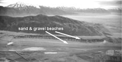
Vigorous canyon streams carrying large amounts of sand and gravel deposited deltas where they flowed into Lake Bonneville. Currents and waves of Lake Bonneville redeposited the sand and gravel along the shoreline as beaches that make up the familiar “bathtub rings” around the Wasatch Front.
Occasionally, if the lake’s shoreline currents were strong and carried a lot of sand and gravel, they would deposit a bar across a narrow gap in a valley; the Point of the Mountain at the south end of the Salt Lake Valley is such a bar.
The deltas, beaches, and bars deposited when Lake Bonneville was at the same elevation for 500 years or so are particularly large. Not surprisingly, these are where most of the sand and gravel pits are located.
Mother Nature has indeed blessed the Wasatch Front with extensive sand and gravel deposits to use for construction and growth.
Survey Notes, v. 33 no. 3, August 2001


